IMAGES TAKEN NEAR TO
Walgrove Gardens, MAIDENHEAD, SL6 3SJ
Introduction
This page details the photographs taken nearby to Walgrove Gardens, SL6 3SJ by members of the Geograph project.
The Geograph project started in 2005 with the aim of publishing, organising and preserving representative images for every square kilometre of Great Britain, Ireland and the Isle of Man.

There are currently over 7.5m images from over14,400 individuals and you can help contribute to the project by visiting https://www.geograph.org.uk
Image Map
Images are licensed for reuse under creativecommons.org/licenses/by-sa/2.0
Notes
- Clicking on the map will re-center to the selected point.
- The higher the marker number, the further away the image location is from the centre of the postcode.
Image Listing (18 Images Found)
Images are licensed for reuse under creativecommons.org/licenses/by-sa/2.0
Image
Details
Distance
1
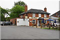
The Beehive, White Waltham
The pub has a good view of the cricket ground. It provides good food and beer including some Marlow Rebellion ones. It describes itself as "dinning pub of the year".
Image: © Bill Boaden
Taken: 11 May 2018
0.06 miles
2
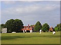
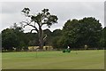
Cricketers on the green, White Waltham
In the background are cottages at the junction of Cannon Lane and Butcher's Lane. The war memorial can also just be seen.
Image: © Andrew Smith
Taken: 28 Jun 2008
0.09 miles
3
Village cricket at White Waltham
An entertaining view while you have a pint at the Beehive.
Image: © Bill Boaden
Taken: 11 May 2018
0.11 miles
4
Preparing to resume matches
Mowing the pitch at White Waltham Cricket Club during the Covid restrictions.
Image: © Simon Mortimer
Taken: 4 Jul 2020
0.12 miles
5
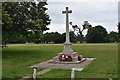
White Waltham War Memorial
The memorial was unveiled in May 1920 to commemorate the 21 residents of the village who died in the First World War.
Image: © Simon Mortimer
Taken: 4 Jul 2020
0.12 miles
6
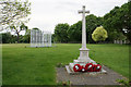
War memorial in White Waltham
Backing onto the cricket ground.
Image: © Bill Boaden
Taken: 11 May 2018
0.13 miles
7
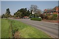
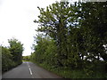
White Waltham
Along the minor road with the Beehive public house on the right and the village cricket green on the left. Apart from a small residential area near this pub the rest of the square is open farmland.
Image: © Brendan and Ruth McCartney
Taken: 21 Apr 2005
0.14 miles
8
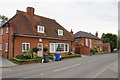
The Old Bakery and the Parish Hall
The Parish Hall to the right is the public building, and it is viewed from the Parish Hall car park on the opposite side of the road.
Image: © Bill Boaden
Taken: 11 May 2018
0.14 miles
9
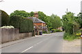
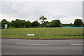
Waltham Road, White Waltham
Quite a good way of skirting the Maidenhead conurbation.
Image: © Bill Boaden
Taken: 11 May 2018
0.16 miles