IMAGES TAKEN NEAR TO
Butchers Lane, MAIDENHEAD, SL6 3SE
Introduction
This page details the photographs taken nearby to Butchers Lane, SL6 3SE by members of the Geograph project.
The Geograph project started in 2005 with the aim of publishing, organising and preserving representative images for every square kilometre of Great Britain, Ireland and the Isle of Man.

There are currently over 7.5m images from over14,400 individuals and you can help contribute to the project by visiting https://www.geograph.org.uk
Image Map
Images are licensed for reuse under creativecommons.org/licenses/by-sa/2.0
Notes
- Clicking on the map will re-center to the selected point.
- The higher the marker number, the further away the image location is from the centre of the postcode.
Image Listing (14 Images Found)
Images are licensed for reuse under creativecommons.org/licenses/by-sa/2.0
Image
Details
Distance
1
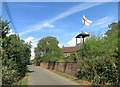
Flag & Watchtower
This is at Shottesbrooke Farm.
Image: © Des Blenkinsopp
Taken: 7 Aug 2014
0.06 miles
2
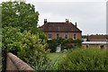
Shottesbrooke Farmhouse
This late 18th Century farmhouse sits on Butchers Lane and is a Grade II Listed Building. It was previously known as Chamber's Farm in Victorian times.
Image: © Simon Mortimer
Taken: 4 Jul 2020
0.08 miles
3
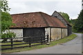
Barn and cowshed at Shottesbrooke Farm
The complex of farm buildings at Stottesbrooke Farm dates back to the 17th Century and is a Grade II Listed Building. The cowshed walls are constructed with chalk blocks or 'clunch'.
Image: © Simon Mortimer
Taken: 4 Jul 2020
0.11 miles
4
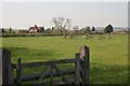
Cold Harbour
Looking north towards Shottesbrook Farm. Apart from the railway line, which bisects the square, the surrounding area is all farmland.
Image: © Brendan and Ruth McCartney
Taken: 21 Apr 2005
0.11 miles
5
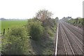
Cold Harbour
Looking southwest along the railway line from the bridge in the east of the square, the rest of which is farmland.
Image: © Brendan and Ruth McCartney
Taken: 21 Apr 2005
0.13 miles
7
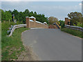
Railway Bridge, Bottle lane
The recently refurbished railway bridge near Shottesbrook Farm.
Image: © Alan Hunt
Taken: 31 May 2013
0.16 miles
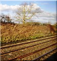
8
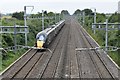
Great Western mainline near Shottesbrooke Farm
Looking west from the Butchers Lane bridge.
Image: © Simon Mortimer
Taken: 4 Jul 2020
0.17 miles
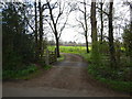
10
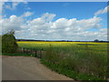
Rapeseed Fields near Shottesbrooke Farm
This road is part of the Knowl Hill Bridleway Circuit.
Image: © James Emmans
Taken: 31 Mar 2017
0.19 miles