IMAGES TAKEN NEAR TO
Bottle Lane, MAIDENHEAD, SL6 3RY
Introduction
This page details the photographs taken nearby to Bottle Lane, SL6 3RY by members of the Geograph project.
The Geograph project started in 2005 with the aim of publishing, organising and preserving representative images for every square kilometre of Great Britain, Ireland and the Isle of Man.

There are currently over 7.5m images from over14,400 individuals and you can help contribute to the project by visiting https://www.geograph.org.uk
Image Map
Images are licensed for reuse under creativecommons.org/licenses/by-sa/2.0
Notes
- Clicking on the map will re-center to the selected point.
- The higher the marker number, the further away the image location is from the centre of the postcode.
Image Listing (18 Images Found)
Images are licensed for reuse under creativecommons.org/licenses/by-sa/2.0
Image
Details
Distance
1
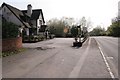
Knowl Hill
Looking southwest along the A4 road in the southeast corner of the square. The square consists of the village of Knowl Hill on the busy A4 and the rest is farmland.
Image: © Brendan and Ruth McCartney
Taken: 21 Apr 2005
0.10 miles
3
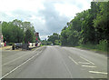
Knowl Hill : Bath Road A4
Looking along Bath Road.
Image: © Lewis Clarke
Taken: 18 Jul 2019
0.13 miles
4
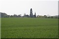
Knowl Hill
Looking west across farmland towards Knowl Hill church from the minor road in the east of the square.
Image: © Brendan and Ruth McCartney
Taken: 21 Apr 2005
0.17 miles
5
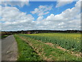
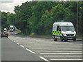
Minor Rural Road
Bottle Lane has passing places.
Image: © James Emmans
Taken: 31 Mar 2017
0.19 miles
6
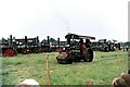
Knowl Hill steam fair ? 1972
This was one of the largest and longest lived steam fairs in the UK. Fowler steam roller 'Ruffle' (PP9257) – works no 17234 of 1927 – parades past a line up of traction engines.
(The precise location and view direction is not known)
Image: © Alan Murray-Rust
Taken: 12 Aug 1972
0.21 miles
7
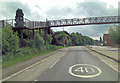
A4 Bath Road passes under Knowl Hill Footbridge
Just beyond the bridge is The Crown public house.
Image: © Stuart Logan
Taken: 6 Jun 2012
0.22 miles
8
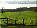
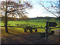
Pasture, Knowl Hill
A footpath makes its way to the village. The church's steeple may just be made out amongst the trees.
Image: © Andrew Smith
Taken: 20 Nov 2008
0.23 miles
9
Pasture, Knowl Hill
The junction of five footpaths at Kiln Cottage. A path can be seen making its way to the village.
Image: © Andrew Smith
Taken: 20 Nov 2008
0.23 miles
10
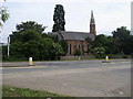
St Peter's Church
Looking across Bath Road (A4) to St Peter's Church Knowl Hill
Image: © Shaun Ferguson
Taken: 12 Jun 2009
0.23 miles