IMAGES TAKEN NEAR TO
Woodlands Park Avenue, MAIDENHEAD, SL6 3LS
Introduction
This page details the photographs taken nearby to Woodlands Park Avenue, SL6 3LS by members of the Geograph project.
The Geograph project started in 2005 with the aim of publishing, organising and preserving representative images for every square kilometre of Great Britain, Ireland and the Isle of Man.

There are currently over 7.5m images from over14,400 individuals and you can help contribute to the project by visiting https://www.geograph.org.uk
Image Map
Images are licensed for reuse under creativecommons.org/licenses/by-sa/2.0
Notes
- Clicking on the map will re-center to the selected point.
- The higher the marker number, the further away the image location is from the centre of the postcode.
Image Listing (8 Images Found)
Images are licensed for reuse under creativecommons.org/licenses/by-sa/2.0
Image
Details
Distance
1
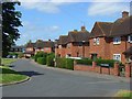
White Paddock. Woodlands Park
Houses on the eastern side of the square formed by the roads at the centre of the estate.
Image: © Andrew Smith
Taken: 28 Jun 2008
0.10 miles
3
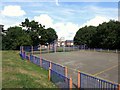
Basketball, Phipps Close
Sports court in a small park in amongst the houses.
Image: © Des Blenkinsopp
Taken: 7 Aug 2014
0.15 miles
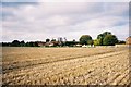
4

Snowball Hill, Woodlands Park
The small industrial estate on the edge of the otherwise residential suburb.
Image: © Andrew Smith
Taken: 28 Jun 2008
0.16 miles
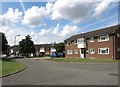
5
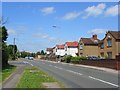
Woodlands Park
An ugly estate on the southwestern edge of Maidenhead.
Image: © Andrew Smith
Taken: 13 Nov 2005
0.22 miles
6
Waltham Road, Woodlands Park
Part of the southwestern suburb of Maidenhead which is in White Waltham parish and beside White Waltham Airfield.
Image: © Andrew Smith
Taken: 28 Jun 2008
0.22 miles
7
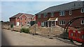
New Residential Development
Near White Waltham village
Image: © James Emmans
Taken: 18 Jun 2015
0.23 miles
8
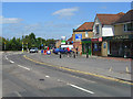
Waltham Road, Woodlands Park
On the approach to the junction with Cannon Lane. The row of shops includes a carpet retailer, Chinese takeaway, convenience store, pharmacy, newsagent and a firm of architects.
Image: © Andrew Smith
Taken: 28 Jun 2008
0.24 miles