IMAGES TAKEN NEAR TO
Hurst Lane, MAIDENHEAD, SL6 3JJ
Introduction
This page details the photographs taken nearby to Hurst Lane, SL6 3JJ by members of the Geograph project.
The Geograph project started in 2005 with the aim of publishing, organising and preserving representative images for every square kilometre of Great Britain, Ireland and the Isle of Man.

There are currently over 7.5m images from over14,400 individuals and you can help contribute to the project by visiting https://www.geograph.org.uk
Image Map
Images are licensed for reuse under creativecommons.org/licenses/by-sa/2.0
Notes
- Clicking on the map will re-center to the selected point.
- The higher the marker number, the further away the image location is from the centre of the postcode.
Image Listing (12 Images Found)
Images are licensed for reuse under creativecommons.org/licenses/by-sa/2.0
Image
Details
Distance
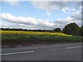
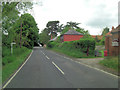
4
B3024 road junction south of Waltham Place
Image: © Stuart Logan
Taken: 6 Jun 2012
0.18 miles
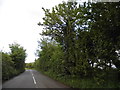
8
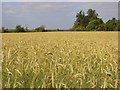
Barley, White Waltham
The crop beside the footpath to the west of Waltham Place.
Image: © Andrew Smith
Taken: 28 Jun 2008
0.21 miles
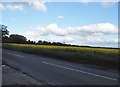
9
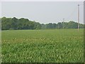
Farmland, White Waltham
A cereal field between the B3024 and the northern edge of Great Wood.
Image: © Andrew Smith
Taken: 21 May 2008
0.23 miles
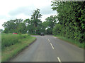
10
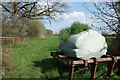
The Bale is Sprouting
By the gate to a footpath. Whatever is in the bale is obviously quite fertile.
Image: © Des Blenkinsopp
Taken: 14 Apr 2018
0.23 miles