IMAGES TAKEN NEAR TO
Woolley Avenue, MAIDENHEAD, SL6 3BF
Introduction
This page details the photographs taken nearby to Woolley Avenue, SL6 3BF by members of the Geograph project.
The Geograph project started in 2005 with the aim of publishing, organising and preserving representative images for every square kilometre of Great Britain, Ireland and the Isle of Man.

There are currently over 7.5m images from over14,400 individuals and you can help contribute to the project by visiting https://www.geograph.org.uk
Image Map
Images are licensed for reuse under creativecommons.org/licenses/by-sa/2.0
Notes
- Clicking on the map will re-center to the selected point.
- The higher the marker number, the further away the image location is from the centre of the postcode.
Image Listing (14 Images Found)
Images are licensed for reuse under creativecommons.org/licenses/by-sa/2.0
Image
Details
Distance
1
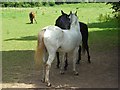
Mutual back-scratching, Woolley Green
In the field at the corner of the A4 and Burchetts Green Lane.
Image: © Andrew Smith
Taken: 28 Jun 2008
0.07 miles
2
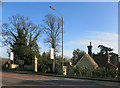
Gates to Woolley Hall
Woolley Hall is a country house dating from 1780 which has recently been acquired by a developer and is to be converted into apartments. http://www.millgatehomes.co.uk/properties/view/woolley-hall1/
Image: © Des Blenkinsopp
Taken: 16 Jan 2015
0.09 miles
3
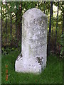
Old Milestone by the A4, Bath Road, Littlewick Green
Carved stone post by the A4, in parish of White Waltham (Windsor and Maidenhead District), Bath Road; between junction with Burchett's Lane and roundabout to industrial park, Littlewick Green, opposite Bath Cottage, behind path where shrubs cut back; back to fence on sown grass; by bus stop sign, on South side of road. Bath Road limestone pillar, erected by the Maidenhead turnpike trust in the 19th century.
Inscription reads:-
: TO / READING / 10 / MILES / BATH / 79 : : Parish of / WALTHAM / 1824 : : TO / HYDE PARK / CORNER / 29 / MILES / MAIDENHEAD / 3 / COLNBROOK / 12 :
Carved benchmark noted in earlier survey.
Grade II listed.
List Entry Number: 1281368 https://historicengland.org.uk/listing/the-list/list-entry/1281368
Milestone Society National ID: BE_LB29
Image: © A Rosevear
Taken: 13 May 2004
0.09 miles
4
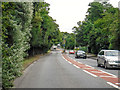
Littlewick Green : Bath Road A4
Looking along Bath Road.
Image: © Lewis Clarke
Taken: 18 Jul 2019
0.09 miles
5
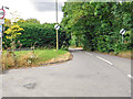
Littlewick Green : Burchett's Green Lane
Looking off Bath Road.
Image: © Lewis Clarke
Taken: 18 Jul 2019
0.11 miles
6
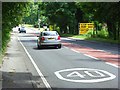
The A4, Woolley Green
This is the approach to Maidenhead Thicket from Littlewick Green. Woolley Green is just off the road to the right. This is the location of a former shire horse visitor attraction. The Shire Horse pub is on the right too.
Image: © Andrew Smith
Taken: 28 Jun 2008
0.11 miles
7
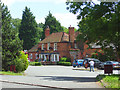
The Shire Horse pub, Woolley Green
A popular pub and eating house beside the A4 near Maidenhead Thicket. It's now part of the Chef and Brewer chain.
Image: © Andrew Smith
Taken: 28 Jun 2008
0.11 miles
8
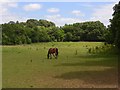
Horse, Woolley Green
A field on the northern side of the A4 with Maidenhead Thicket at its far end.
Image: © Andrew Smith
Taken: 28 Jun 2008
0.15 miles
9
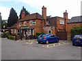
The Shire Horse at Woolley Green
The pub is part of the Chef & Brewer chain.
Image: © Steve Daniels
Taken: 16 Jun 2012
0.18 miles
10
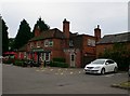
The Shire Horse, Littlewick Green
A traditional country pub near Littlewick Green on the A4 Bath Road, just outside Maidenhead on the road to Reading. It’s an attractive, 18th century building that used to be a coaching inn.
Image: © Eirian Evans
Taken: 2 Jul 2013
0.18 miles