IMAGES TAKEN NEAR TO
Hillmead Court, MAIDENHEAD, SL6 0QA
Introduction
This page details the photographs taken nearby to Hillmead Court, SL6 0QA by members of the Geograph project.
The Geograph project started in 2005 with the aim of publishing, organising and preserving representative images for every square kilometre of Great Britain, Ireland and the Isle of Man.

There are currently over 7.5m images from over14,400 individuals and you can help contribute to the project by visiting https://www.geograph.org.uk
Image Map
Images are licensed for reuse under creativecommons.org/licenses/by-sa/2.0
Notes
- Clicking on the map will re-center to the selected point.
- The higher the marker number, the further away the image location is from the centre of the postcode.
Image Listing (5 Images Found)
Images are licensed for reuse under creativecommons.org/licenses/by-sa/2.0
Image
Details
Distance
1
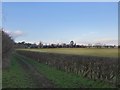
Farmland, seen from Boundary Road
The view is in the general direction of Hitcham.
Image: © Stefan Czapski
Taken: 13 Jan 2014
0.10 miles
2
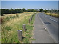
Taplow: Boundary Road
Looking towards Taplow, with the spire of Taplow Church Image just visible to the right of the distant road sign.
Image: © Nigel Cox
Taken: 19 Jul 2006
0.16 miles
3
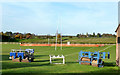
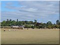
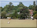
Rugby Posts and Rollers
Sports ground near Taplow station.
Image: © Des Blenkinsopp
Taken: 15 Nov 2013
0.20 miles