IMAGES TAKEN NEAR TO
Farm Road, MAIDENHEAD, SL6 0PT
Introduction
This page details the photographs taken nearby to Farm Road, SL6 0PT by members of the Geograph project.
The Geograph project started in 2005 with the aim of publishing, organising and preserving representative images for every square kilometre of Great Britain, Ireland and the Isle of Man.

There are currently over 7.5m images from over14,400 individuals and you can help contribute to the project by visiting https://www.geograph.org.uk
Image Map
Images are licensed for reuse under creativecommons.org/licenses/by-sa/2.0
Notes
- Clicking on the map will re-center to the selected point.
- The higher the marker number, the further away the image location is from the centre of the postcode.
Image Listing (2 Images Found)
Images are licensed for reuse under creativecommons.org/licenses/by-sa/2.0
Image
Details
Distance
1
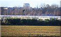
Glasshouses at West Town Farm
Most of SU9280 is occupied by the fields and buildings of West Town Farm.
Image: © Des Blenkinsopp
Taken: 19 Feb 2019
0.08 miles
2
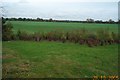
Burnham: West Town Farm
A view taken looking north eastwards from the Jubilee River across flat arable farmland towards West Town Farm.
Image: © Nigel Cox
Taken: 28 Oct 2005
0.08 miles