IMAGES TAKEN NEAR TO
Lake End Road, MAIDENHEAD, SL6 0PN
Introduction
This page details the photographs taken nearby to Lake End Road, SL6 0PN by members of the Geograph project.
The Geograph project started in 2005 with the aim of publishing, organising and preserving representative images for every square kilometre of Great Britain, Ireland and the Isle of Man.

There are currently over 7.5m images from over14,400 individuals and you can help contribute to the project by visiting https://www.geograph.org.uk
Image Map
Images are licensed for reuse under creativecommons.org/licenses/by-sa/2.0
Notes
- Clicking on the map will re-center to the selected point.
- The higher the marker number, the further away the image location is from the centre of the postcode.
Image Listing (23 Images Found)
Images are licensed for reuse under creativecommons.org/licenses/by-sa/2.0
Image
Details
Distance
1
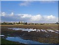
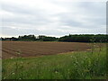
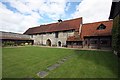
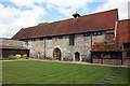
More rain on the way: fields north of Burnham Abbey, January 2014
Compared with much of this stretch of the Thames Valley in late January 2014, the fields in front of the camera were pretty dry. The rain caught up with me half an hour later, at Dorney - and it pelted down.
Image: © Stefan Czapski
Taken: 28 Jan 2014
0.12 miles
2
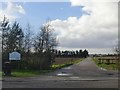
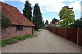
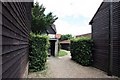
Entrance to West Town Farm
Immediately west of Burnham Abbey.
Image: © Stefan Czapski
Taken: 28 Jan 2014
0.17 miles