IMAGES TAKEN NEAR TO
Orkney Court, MAIDENHEAD, SL6 0JB
Introduction
This page details the photographs taken nearby to Orkney Court, SL6 0JB by members of the Geograph project.
The Geograph project started in 2005 with the aim of publishing, organising and preserving representative images for every square kilometre of Great Britain, Ireland and the Isle of Man.

There are currently over 7.5m images from over14,400 individuals and you can help contribute to the project by visiting https://www.geograph.org.uk
Image Map
Images are licensed for reuse under creativecommons.org/licenses/by-sa/2.0
Notes
- Clicking on the map will re-center to the selected point.
- The higher the marker number, the further away the image location is from the centre of the postcode.
Image Listing (4 Images Found)
Images are licensed for reuse under creativecommons.org/licenses/by-sa/2.0
Image
Details
Distance
1
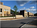
New Housing on site of former Canadian Red Cross Memorial Hospital
This is a real photo!-not an architect's mock up!-of real houses.
Image: © Kevin White
Taken: 31 May 2009
0.11 miles
3
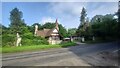
Windsor Lodge
1860 Grade II listed lodge house for Cliveden with the Duke of Sutherland initials. Thought to be built by George Devey.
Image: © James Emmans
Taken: 1 Jul 2021
0.15 miles
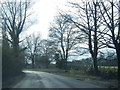
4
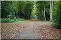
Cliveden Green Drive
Cliveden Green Drive with the path to the right going down to Duke's Statue
Image: © Shaun Ferguson
Taken: 24 Oct 2007
0.22 miles