IMAGES TAKEN NEAR TO
Rutland Close, MAIDENHEAD, SL6 0FA
Introduction
This page details the photographs taken nearby to Rutland Close, SL6 0FA by members of the Geograph project.
The Geograph project started in 2005 with the aim of publishing, organising and preserving representative images for every square kilometre of Great Britain, Ireland and the Isle of Man.

There are currently over 7.5m images from over14,400 individuals and you can help contribute to the project by visiting https://www.geograph.org.uk
Image Map
Images are licensed for reuse under creativecommons.org/licenses/by-sa/2.0
Notes
- Clicking on the map will re-center to the selected point.
- The higher the marker number, the further away the image location is from the centre of the postcode.
Image Listing (77 Images Found)
Images are licensed for reuse under creativecommons.org/licenses/by-sa/2.0
Image
Details
Distance
1
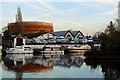
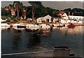
Gasometer & Boathouses on the Thames
Not far north of Maidenhead Bridge
Image: © Lee Kindness
Taken: 19 Nov 2005
0.08 miles
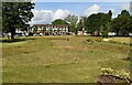
2
Grassed area between River Thames and Jubilee River
Image: © N Chadwick
Taken: 9 Jun 2019
0.08 miles
8
River Thames
Close to The Maidenhead Bridge
Image: © HENRY CLARK
Taken: 24 May 1985
0.11 miles