IMAGES TAKEN NEAR TO
Amerden Close, MAIDENHEAD, SL6 0EF
Introduction
This page details the photographs taken nearby to Amerden Close, SL6 0EF by members of the Geograph project.
The Geograph project started in 2005 with the aim of publishing, organising and preserving representative images for every square kilometre of Great Britain, Ireland and the Isle of Man.

There are currently over 7.5m images from over14,400 individuals and you can help contribute to the project by visiting https://www.geograph.org.uk
Image Map
Images are licensed for reuse under creativecommons.org/licenses/by-sa/2.0
Notes
- Clicking on the map will re-center to the selected point.
- The higher the marker number, the further away the image location is from the centre of the postcode.
Image Listing (50 Images Found)
Images are licensed for reuse under creativecommons.org/licenses/by-sa/2.0
Image
Details
Distance
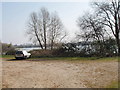
2

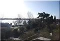
Lake at Amerden
Lake near Taplow used for aquatic sports, sited next to the Jubilee River.
http://www.jubileeriver.co.uk/
Image: © Colin Smith
Taken: 28 Mar 2012
0.06 miles
3
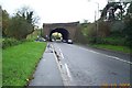
Taplow: railway bridge over the A4 road
A fine skewed bridge taking the main railway line from Paddington to Reading and the west over the A4 Bath Road. (NB The grid line between SU9081 and SU9181 absolutely bisects this bridge, but there were 5 images already in SU9081 and none in SU9181, so...!!)
Image: © Nigel Cox
Taken: 28 Oct 2005
0.07 miles
6
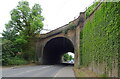
Taplow Lake
View at the entrance to Taplow Lake Sailing Club. For more information and photos for Taplow see community website http://www.taplow.org.uk/.
Image: © David Hawgood
Taken: 26 Mar 2007
0.08 miles

8
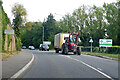
Tractor and trailer on A4 Bath Road
It seems kitted out for market gardening.
Image: © Robin Webster
Taken: 26 Sep 2021
0.09 miles
9
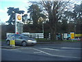
Entrance to Shell garage on Bath Road, Taplow
Image: © David Howard
Taken: 19 Feb 2012
0.09 miles
10
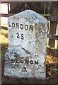
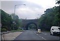
Old Milestone by the A4, east of Maidenhead
Carved stone post by the A4, in parish of Taplow (South Bucks District), Bath Road; West of Railway bridge, beside petrol station, opposite pub (was Dumb Bell Hotel), on well kept grass verge in front of fence, on South side of road. Bath Road limestone diamond, erected by the Colnbrook, Datchet & Slough turnpike trust in the 18th century.
Inscription reads:-
: MAIDENHEAD / 1 : : LONDON / 25 : : SLOUGH / 4 :
Buckinghamshire HER.
HER Number: 1360200000 https://www.heritagegateway.org.uk/Gateway/Results_Single.aspx?uid=MBC25794&resourceID=1024
Milestone Society National ID: BU_LB25
Image: © A Rosevear & J Higgins
Taken: 28 Sep 2001
0.10 miles