IMAGES TAKEN NEAR TO
Glebe Close, MAIDENHEAD, SL6 0DL
Introduction
This page details the photographs taken nearby to Glebe Close, SL6 0DL by members of the Geograph project.
The Geograph project started in 2005 with the aim of publishing, organising and preserving representative images for every square kilometre of Great Britain, Ireland and the Isle of Man.

There are currently over 7.5m images from over14,400 individuals and you can help contribute to the project by visiting https://www.geograph.org.uk
Image Map
Images are licensed for reuse under creativecommons.org/licenses/by-sa/2.0
Notes
- Clicking on the map will re-center to the selected point.
- The higher the marker number, the further away the image location is from the centre of the postcode.
Image Listing (30 Images Found)
Images are licensed for reuse under creativecommons.org/licenses/by-sa/2.0
Image
Details
Distance
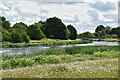
2
Jubilee River: Footbridge near Glebe Close, Dorney Reach
This is a view taken looking downstream. The man-made Jubilee River was designed to provide flood protection for property in Maidenhead, Windsor, and Eton.
Image: © Nigel Cox
Taken: 28 Oct 2005
0.05 miles

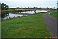
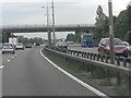
5

M4 Marsh Lane road bridge
Towards Bray.
Image: © Julian P Guffogg
Taken: 7 Aug 2013
0.06 miles
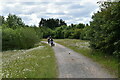
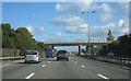
6
M4 bridge carries Marsh Lane
Marsh Lane connects Dorney reach to Maidenhead and Slough.
Image: © Stuart Logan
Taken: 24 Aug 2011
0.07 miles