IMAGES TAKEN NEAR TO
Stockwells, MAIDENHEAD, SL6 0DB
Introduction
This page details the photographs taken nearby to Stockwells, SL6 0DB by members of the Geograph project.
The Geograph project started in 2005 with the aim of publishing, organising and preserving representative images for every square kilometre of Great Britain, Ireland and the Isle of Man.

There are currently over 7.5m images from over14,400 individuals and you can help contribute to the project by visiting https://www.geograph.org.uk
Image Map
Images are licensed for reuse under creativecommons.org/licenses/by-sa/2.0
Notes
- Clicking on the map will re-center to the selected point.
- The higher the marker number, the further away the image location is from the centre of the postcode.
Image Listing (32 Images Found)
Images are licensed for reuse under creativecommons.org/licenses/by-sa/2.0
Image
Details
Distance
2
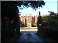
Taplow Court through the gate
A Victorian house built on the site of much earlier buildings. Now used as a Buddhist retreat.
Image: © Bikeboy
Taken: 12 Oct 2013
0.07 miles
3
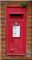
Elizabeth II postbox on Cliveden Road, Taplow
Postbox No. SL6 40.
See Image] for context.
Image: © JThomas
Taken: 26 May 2022
0.07 miles
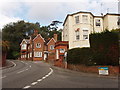
4
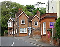
House for sale on Cliveden Road, Taplow
Showing position of Postbox No. SL6 40.
See Image] for postbox.
Image: © JThomas
Taken: 26 May 2022
0.08 miles
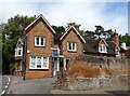
6
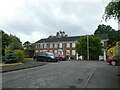
Taplow village centre
Houses on Cliveden Road, at the junction with Rectory Road
Image: © David Hawgood
Taken: 1 Oct 2005
0.08 miles
8

Taeppa's Mound / Taplow Barrow
This seventh century burial mound stands in the grounds of Taplow Court. It is 15 feet high, 80 feet in diameter and 240 feet in circumference.
It would later be surpassed by Sutton Hoo, but when the Taplow site was excavated in 1883 it was the richest Saxon burial in the country.
Interred beneath the mound was a single individual - interpreted by archaeologists as a local chieftain - buried with grave goods including a sword, three spears, two shields, drinking horns and glass beakers.
These are now displayed in the British Museum.
Image: © Mark Percy
Taken: 3 Sep 2023
0.11 miles
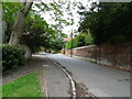
9
Navigating northwards up the Bashire (48)
Looking across Cliveden Road towards Taplow Court
Image: © Basher Eyre
Taken: 3 Jul 2024
0.11 miles
10
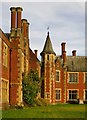
Turret and chimneys, Taplow Court
There had been earlier grand houses on this hilltop, but this one dates from 1855. In the Buckinghamshire volume of 'The Buildings of England', Pevsner describes it as 'Big, Early Tudor'. Big it certainly is, but it puzzles me that Pevsner seems not to have noticed the building's French flavour. The turret seen here is one rather French feature, but there are others: http://www.geograph.org.uk/photo/3816827
Taplow Court was built right next to an old churchyard, and may even have encroached upon it - notice the tomb within a few feet of a window.
Image: © Stefan Czapski
Taken: 14 Jan 2014
0.11 miles