IMAGES TAKEN NEAR TO
Mill Lane, MAIDENHEAD, SL6 0AG
Introduction
This page details the photographs taken nearby to Mill Lane, SL6 0AG by members of the Geograph project.
The Geograph project started in 2005 with the aim of publishing, organising and preserving representative images for every square kilometre of Great Britain, Ireland and the Isle of Man.

There are currently over 7.5m images from over14,400 individuals and you can help contribute to the project by visiting https://www.geograph.org.uk
Image Map
Images are licensed for reuse under creativecommons.org/licenses/by-sa/2.0
Notes
- Clicking on the map will re-center to the selected point.
- The higher the marker number, the further away the image location is from the centre of the postcode.
Image Listing (60 Images Found)
Images are licensed for reuse under creativecommons.org/licenses/by-sa/2.0
Image
Details
Distance
3
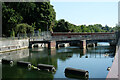
Maidenhead : Jubilee River weir
The Jubilee River is a man-made flood allevation scheme - https://www.gov.uk/government/publications/jubilee-river-flood-alleviation-scheme/jubilee-river-flood-alleviation-scheme.
Image: © Jim Osley
Taken: 12 Aug 2022
0.08 miles
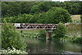
4
Taplow Paper Mills
Now closed,and proposed for redevelopment along with Skindles site. (Another 20 yrs?)
Image: © Kevin White
Taken: 25 Sep 2009
0.09 miles
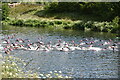
8
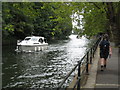
The Thames Path approaching Maidenhead bridge
Image: © Rod Allday
Taken: 27 Aug 2008
0.12 miles