IMAGES TAKEN NEAR TO
Birch Lane, ASCOT, SL5 8RF
Introduction
This page details the photographs taken nearby to Birch Lane, SL5 8RF by members of the Geograph project.
The Geograph project started in 2005 with the aim of publishing, organising and preserving representative images for every square kilometre of Great Britain, Ireland and the Isle of Man.

There are currently over 7.5m images from over14,400 individuals and you can help contribute to the project by visiting https://www.geograph.org.uk
Image Map
Images are licensed for reuse under creativecommons.org/licenses/by-sa/2.0
Notes
- Clicking on the map will re-center to the selected point.
- The higher the marker number, the further away the image location is from the centre of the postcode.
Image Listing (14 Images Found)
Images are licensed for reuse under creativecommons.org/licenses/by-sa/2.0
Image
Details
Distance
1
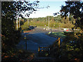
Roundabout, Longhill Road
The roundabout at the junction of Longhill Road and Harvest Ride from the footpath around the landfill site on the outskirts of Bracknell.
Image: © Alan Hunt
Taken: 4 Nov 2014
0.13 miles
2
Longhill Park
The object in the air is a kite.
Image: © Julian P Guffogg
Taken: 7 Jun 2008
0.13 miles
3
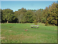
Longhill Park, Bracknell
A bench on the northern side of Longhill Park, a former landfill site now used as a recreation area.
Image: © Alan Hunt
Taken: 4 Nov 2014
0.14 miles
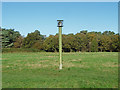
4
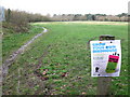
Grow your own birdhouse sign at Longhill Park
A sign advertising the Tree O'Clock campaign to plant a world record number of trees on 5/12/2009
Image: © don cload
Taken: 1 Dec 2009
0.20 miles
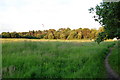
5
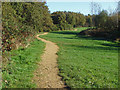
Longhill Park, Bracknell
One of the paths around the edge of the former landfill site now designated as a recreation area.
Image: © Alan Hunt
Taken: 4 Nov 2014
0.21 miles
6
Methane vent, Longhill Park
A methane vent on this former landfill site now a recreation area to the northeast of Bracknell
Image: © Alan Hunt
Taken: 4 Nov 2014
0.21 miles
7
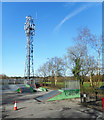
Mast at Longhill Park
This is at the southern end of Longhill Park, a former council tip now landscaped into a recreation area.
Image: © Des Blenkinsopp
Taken: 13 Mar 2017
0.21 miles
8
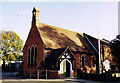
St Martin, Chavey Down
Built as a Mission Church in Victorian times.
Image: © Michael FORD
Taken: Unknown
0.22 miles
9
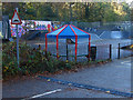
Longhill skateboard park, bracknell
The skateboard park off the entrance road to Longhill Park on the outskirts of Bracknell.
Image: © Alan Hunt
Taken: 4 Nov 2014
0.22 miles
10
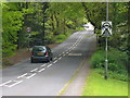
Long Hill Road
Leafy through road, with speed restrictions, from Chavey Down to Martin's Heron on the east edge of Bracknell.
Image: © Colin Smith
Taken: 9 May 2010
0.23 miles