IMAGES TAKEN NEAR TO
King Edwards Road, ASCOT, SL5 8NY
Introduction
This page details the photographs taken nearby to King Edwards Road, SL5 8NY by members of the Geograph project.
The Geograph project started in 2005 with the aim of publishing, organising and preserving representative images for every square kilometre of Great Britain, Ireland and the Isle of Man.

There are currently over 7.5m images from over14,400 individuals and you can help contribute to the project by visiting https://www.geograph.org.uk
Image Map (21 Images)


Getting Data...Please wait
Leaflet Map data © OpenStreetMap
Images are licensed for reuse under creativecommons.org/licenses/by-sa/2.0
Notes
- Clicking on the map will re-center to the selected point.
- The higher the marker number, the further away the image location is from the centre of the postcode.
Image Listing (21 Images Found)
Images are licensed for reuse under creativecommons.org/licenses/by-sa/2.0
Image
Details
Distance
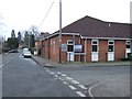
1
Bower Walk
The end of Bower Walk with Blackmoor Pond on the right.
Image: © Alan Hunt
Taken: 25 Apr 2013
0.13 miles
2
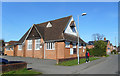
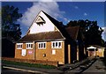
Chapel of St Mary and St John
A neighbourhood church, part of the parish of All Saints', Ascot Heath.
Image: © Des Blenkinsopp
Taken: 13 Mar 2017
0.14 miles
3
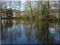
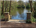
Blackmoor Pond
The view across the pond with the houses on Bower Walk in the background.
Image: © Alan Hunt
Taken: 25 Apr 2013
0.14 miles
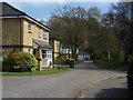
4
Blackmoor Pond, Burleigh
A small pond in the housing estates to the east of Fernbank Road. The pond is not marked on the OS maps prior to the 1913 edition and may have been a sandpit before that date. It now forms part of a recreation area that includes the Blythewood recreation area.
Image: © Alan Hunt
Taken: 25 Apr 2013
0.14 miles
6
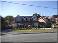
New houses on Fernbank Road, North Ascot
Image: © David Howard
Taken: 19 Jul 2015
0.15 miles
7
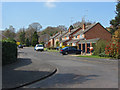
New Meadow
A short cul-de-sac in the 1960s housing estates of Burleigh.
Image: © Alan Hunt
Taken: 25 Apr 2013
0.17 miles
8
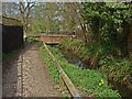
Blackmoor Stream
The blackmoor stream that feeds into Blackmoor Pond just beyond the bridge. This north south running stream forms a boundary between the estate to the west built during the 1960s and the estate to the east built during the 1980s
Image: © Alan Hunt
Taken: 25 Apr 2013
0.18 miles
9
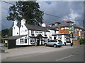
Ascot: Royal Hunt public house
A Greene King house on New Road.
Image: © Nigel Cox
Taken: 21 Jun 2007
0.18 miles