IMAGES TAKEN NEAR TO
Forest Close, ASCOT, SL5 8DW
Introduction
This page details the photographs taken nearby to Forest Close, SL5 8DW by members of the Geograph project.
The Geograph project started in 2005 with the aim of publishing, organising and preserving representative images for every square kilometre of Great Britain, Ireland and the Isle of Man.

There are currently over 7.5m images from over14,400 individuals and you can help contribute to the project by visiting https://www.geograph.org.uk
Image Map
Images are licensed for reuse under creativecommons.org/licenses/by-sa/2.0
Notes
- Clicking on the map will re-center to the selected point.
- The higher the marker number, the further away the image location is from the centre of the postcode.
Image Listing (20 Images Found)
Images are licensed for reuse under creativecommons.org/licenses/by-sa/2.0
Image
Details
Distance
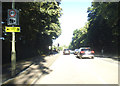
2
Fernbank Road at the junction of London Road
Image: © David Howard
Taken: 19 Jul 2015
0.07 miles
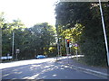
3
London Road entering Ascot
Compare with the earlier visit http://www.geograph.org.uk/photo/3345410
Image: © David Howard
Taken: 19 Jul 2015
0.13 miles
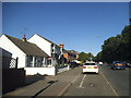
4
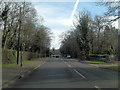
A329 London Road north of Englemere Pond
Image: © Stuart Logan
Taken: 7 Feb 2013
0.13 miles
5
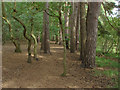
Pine grove
A group of pines growing near the bank of Englemere Pond.
Image: © Alan Hunt
Taken: 1 Sep 2012
0.14 miles
7
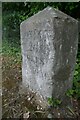
Old Milestone by the A329 at the B3017 junction
Opposite The Royal Foresters
Image: © Andrew Radgick
Taken: 28 Jul 2022
0.17 miles
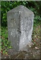
8
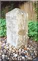
Old Milestone by the A329 at the B3019 junction
Carved stone post by the A329, in parish of Winkfield (Bracknell Forest District), London Road; opposite Royal Foresters Hotel at crossroads with Priory Road, on the verge between road and a wooden fence just before traffic lights, on South side of road. Wokingham square, erected by the Windsor Forest turnpike trust in the 19th century.
Inscription reads:-
LONDON
26
MILES
READING
13
MILES
Grade II listed.
List Entry Number: 1390459 https://historicengland.org.uk/listing/the-list/list-entry/1390459
Milestone Society National ID: BE_LRV26
Image: © A Rosevear
Taken: 28 Aug 2002
0.17 miles
9
Old Milestone by the A329 at the B3017 junction
Opposite The Royal Foresters
Image: © Andrew Radgick
Taken: 28 Jul 2022
0.17 miles
10
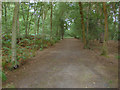
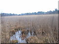
Three castles path
The three castles path, a long distance footpath running through the Englemere Pond local nature reserve.
Image: © Alan Hunt
Taken: 1 Sep 2012
0.17 miles