IMAGES TAKEN NEAR TO
Swinley Road, ASCOT, SL5 8AY
Introduction
This page details the photographs taken nearby to Swinley Road, SL5 8AY by members of the Geograph project.
The Geograph project started in 2005 with the aim of publishing, organising and preserving representative images for every square kilometre of Great Britain, Ireland and the Isle of Man.

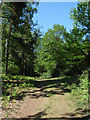
There are currently over 7.5m images from over14,400 individuals and you can help contribute to the project by visiting https://www.geograph.org.uk
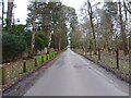
Image Map
Images are licensed for reuse under creativecommons.org/licenses/by-sa/2.0
Notes
- Clicking on the map will re-center to the selected point.
- The higher the marker number, the further away the image location is from the centre of the postcode.
Image Listing (18 Images Found)
Images are licensed for reuse under creativecommons.org/licenses/by-sa/2.0
Image
Details
Distance
1
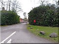
Berkshire Golf Club exit
The exit from the Berkshire Golf Club on the A332 (Swinley Road). There is a postbox which can't be used much.
Image: © Oscar Taylor
Taken: 2 Apr 2023
0.01 miles
2
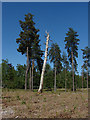
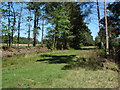
Swinley Forest
A stand of pines, including this wonderful dead trunk, left after the area had been cleared. Dead trees such as this are important for wildlife and should be preserved until they fall naturally.
Image: © Alan Hunt
Taken: 23 May 2010
0.03 miles
3
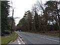
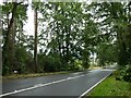
Swinley Road (A332)
Looking north on Swinley Road (the A332) towards Ascot, from the exit from the Berkshire Golf Club.
Image: © Oscar Taylor
Taken: 2 Apr 2023
0.04 miles
4
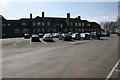
Ascot
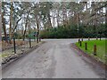
The Club House of the Berkshire Golf Club, off the A332.
Image: © Brendan and Ruth McCartney
Taken: Unknown
0.06 miles
5
Swinley Forest
The short track leading to Buttersteep Rise and the end of the forest. On the right of shot is the garden of one of the houses.
Image: © Alan Hunt
Taken: 23 May 2010
0.06 miles
6
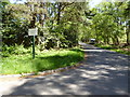
Buttersteep Rise junction
The junction to Swinley Road (the A332) at the end of Buttersteep Rise, a cul-de-sac leading to Buttersteep House. To the left are ancillary buildings of the Berkshire Golf Club.
Image: © Oscar Taylor
Taken: 2 Apr 2023
0.08 miles
7
Buttersteep Rise
This was taken from the junction with Swinley Road
Image: © Shazz
Taken: 13 May 2015
0.09 miles
8
Swinley Forest
The western end of Godens Ride
Image: © Alan Hunt
Taken: 23 May 2010
0.11 miles
9
Buttersteep Rise
A cul-de-sac off Swinley Road (the A332), leading to Buttersteep House.
Image: © Oscar Taylor
Taken: 2 Apr 2023
0.13 miles
10
Navigating northwards up the Basher (31)
Looking south-southeast along the A332
Image: © Basher Eyre
Taken: 31 Jul 2023
0.15 miles