IMAGES TAKEN NEAR TO
Kings Ride, ASCOT, SL5 8AL
Introduction
This page details the photographs taken nearby to Kings Ride, SL5 8AL by members of the Geograph project.
The Geograph project started in 2005 with the aim of publishing, organising and preserving representative images for every square kilometre of Great Britain, Ireland and the Isle of Man.

There are currently over 7.5m images from over14,400 individuals and you can help contribute to the project by visiting https://www.geograph.org.uk
Image Map
Images are licensed for reuse under creativecommons.org/licenses/by-sa/2.0
Notes
- Clicking on the map will re-center to the selected point.
- The higher the marker number, the further away the image location is from the centre of the postcode.
Image Listing (14 Images Found)
Images are licensed for reuse under creativecommons.org/licenses/by-sa/2.0
Image
Details
Distance
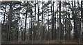
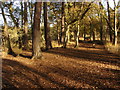
3
Englemere Pond nature reserve
A track running parallel to the railway on the other side of the fence. This area is a recreated heathland habitat.
Image: © Alan Hunt
Taken: 3 Sep 2012
0.16 miles
4
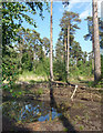
Pool & Pines
Part of Englemere Pond Nature Reserve, a remnant piece of what a lot of this area would have looked like before Bracknell and Ascot spread over it.
Image: © Des Blenkinsopp
Taken: 20 May 2018
0.16 miles
5
Kings Ride Park
A small business park off Kings Ride.
Image: © Des Blenkinsopp
Taken: 20 May 2018
0.19 miles
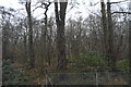
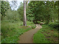
6
Englemere Pond
The path through the trees near the edge of Englemere Pond, a small nature reserve near Ascot.
Image: © Alan Hunt
Taken: 11 Nov 2012
0.19 miles
7
Englemere Pond nature reserve
A sinuous wooden walkway leading away from the carpark into the woods.
Image: © Alan Hunt
Taken: 1 Sep 2012
0.21 miles
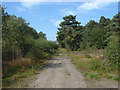
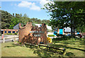
8
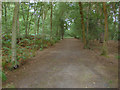
Three castles path
The three castles path, a long distance footpath running through the Englemere Pond local nature reserve.
Image: © Alan Hunt
Taken: 1 Sep 2012
0.21 miles
9
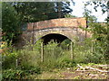
Railway bridge, Englemere Pond.
The bridge carrying the Swinley Road over the railway line.
Image: © Alan Hunt
Taken: 3 Sep 2012
0.22 miles
10
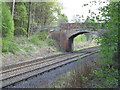
Bridge over the Railway
This bridge carries the B3017 over the Reading to Waterloo line.
Image: © don cload
Taken: 28 Apr 2009
0.22 miles