IMAGES TAKEN NEAR TO
King Stable Street, WINDSOR, SL4 6RH
Introduction
This page details the photographs taken nearby to King Stable Street, SL4 6RH by members of the Geograph project.
The Geograph project started in 2005 with the aim of publishing, organising and preserving representative images for every square kilometre of Great Britain, Ireland and the Isle of Man.

There are currently over 7.5m images from over14,400 individuals and you can help contribute to the project by visiting https://www.geograph.org.uk
Image Map
Images are licensed for reuse under creativecommons.org/licenses/by-sa/2.0
Notes
- Clicking on the map will re-center to the selected point.
- The higher the marker number, the further away the image location is from the centre of the postcode.
Image Listing (587 Images Found)
Images are licensed for reuse under creativecommons.org/licenses/by-sa/2.0
Image
Details
Distance
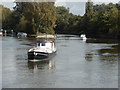
2
The Thames from Windsor Bridge
This view is looking upstream (east).
Image: © mike smith
Taken: 27 Mar 2011
0.03 miles
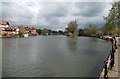
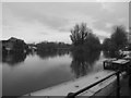
3
Downstream from Windsor Bridge
Looking surprisingly rural
Image: © Graham Walter
Taken: 25 Sep 1999
0.03 miles
4
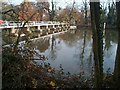
Towards Romney Island, Windsor
A view from Thames Side looking along the River Thames
towards Romney Island http://www.geograph.org.uk/photo/2967046 and the nearby weir.
Image: © Jaggery
Taken: 27 Apr 2013
0.03 miles
5
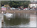
Car driving up the Thames
Taken from the Eton bank
Image: © Graham Walter
Taken: 16 Jun 1999
0.03 miles
6
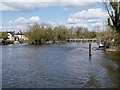
River Thames, Looking towards the Weir at Windsor
Image: © David Dixon
Taken: 11 Apr 2015
0.03 miles
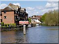
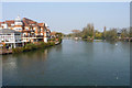
9
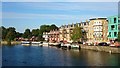
Windsor riverside
The view downstream from Windsor Town Bridge.
Image: © Mark Percy
Taken: 10 Jul 2018
0.04 miles
10
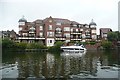
Eton, you can't afford one
A block of very expensive apartments on the Eton riverbank, just downstream of the bridge and upstream of the weir.
Image: © Graham Horn
Taken: 24 Aug 2008
0.04 miles