IMAGES TAKEN NEAR TO
Boveney Road, WINDSOR, SL4 6QD
Introduction
This page details the photographs taken nearby to Boveney Road, SL4 6QD by members of the Geograph project.
The Geograph project started in 2005 with the aim of publishing, organising and preserving representative images for every square kilometre of Great Britain, Ireland and the Isle of Man.

There are currently over 7.5m images from over14,400 individuals and you can help contribute to the project by visiting https://www.geograph.org.uk
Image Map
Images are licensed for reuse under creativecommons.org/licenses/by-sa/2.0
Notes
- Clicking on the map will re-center to the selected point.
- The higher the marker number, the further away the image location is from the centre of the postcode.
Image Listing (8 Images Found)
Images are licensed for reuse under creativecommons.org/licenses/by-sa/2.0
Image
Details
Distance
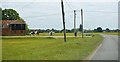
1
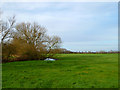
Boveney Road
Boveney Road on Dorney Common heading towards Boveney
Image: © Shaun Ferguson
Taken: 3 Oct 2012
0.01 miles
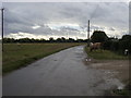
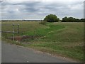
4
Common, Dorney
The southern edge of the common with Cress Brook to the left.
Image: © Andrew Smith
Taken: 27 Feb 2011
0.15 miles
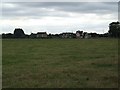
5
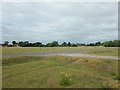
Dorney Common
The large common used for cattle grazing.
Image: © James Emmans
Taken: 25 Jun 2017
0.24 miles
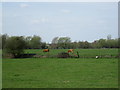
6
Cress Brook
Little water visible in this season.
Image: © Martyn Davies
Taken: 24 Aug 2009
0.24 miles
7
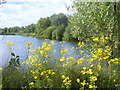
Pond at Dorney Lake
Large pond in the Arboretum beside Dorney Rowing Lake.
http://www.dorneylake.co.uk/
Image: © Colin Smith
Taken: 14 Aug 2011
0.24 miles