IMAGES TAKEN NEAR TO
Stonebridge Field, WINDSOR, SL4 6PR
Introduction
This page details the photographs taken nearby to Stonebridge Field, SL4 6PR by members of the Geograph project.
The Geograph project started in 2005 with the aim of publishing, organising and preserving representative images for every square kilometre of Great Britain, Ireland and the Isle of Man.

There are currently over 7.5m images from over14,400 individuals and you can help contribute to the project by visiting https://www.geograph.org.uk
Image Map
Images are licensed for reuse under creativecommons.org/licenses/by-sa/2.0
Notes
- Clicking on the map will re-center to the selected point.
- The higher the marker number, the further away the image location is from the centre of the postcode.
Image Listing (47 Images Found)
Images are licensed for reuse under creativecommons.org/licenses/by-sa/2.0
Image
Details
Distance
1
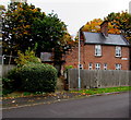
Sandles Cottages, Eton
Semi-detached cottages viewed across the road named Stonebridge Field.
Image: © Jaggery
Taken: 24 Oct 2015
0.01 miles
2
Stonebridge Field, Eton
Stonebridge Field is a dead-end residential street.
Viewed across Broken Furlong near the corner of Eton Wick Road.
Image: © Jaggery
Taken: 24 Oct 2015
0.01 miles
3
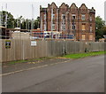
Sandles building site, Eton
Viewed across Stonebridge Field in late October 2015. A nearby Notice of Construction Project states that the work in progress is the conversion, extension and refurbishment of The Sandles to provide 7 self-contained flats. The project also includes the demolition of Rose Cottage and erection of 5 terraced houses.
Work began here on February 2nd 2015 and is scheduled to last for 64 weeks.
Image: © Jaggery
Taken: 24 Oct 2015
0.02 miles
4
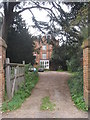
Former Eton College Sanatorium
Now converted to flats.
Image: © Jonathan Thacker
Taken: 13 Oct 2010
0.03 miles
5
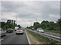
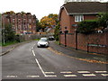
The A332 into Windsor
Taken in a traffic jam while entering Windsor
Image: © Ian S
Taken: 1 Jun 2012
0.04 miles
6
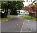
Broken Furlong, Eton
Residential street on the north side of Eton Wick Road.
Image: © Jaggery
Taken: 24 Oct 2015
0.05 miles
7
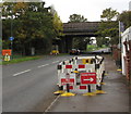
Gas mains road works, Eton Wick Road, Eton
No smoking near these roadworks viewed in late October 2015.
The A332 Royal Windsor Way overbridge is in the background.
Image: © Jaggery
Taken: 24 Oct 2015
0.06 miles
8
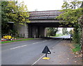
East side of the A332 overbridge, Eton Wick Road, Eton
The bridge carries the A332 Royal Windsor Way over the B3026 Eton Wick Road.
Image: © Jaggery
Taken: 24 Oct 2015
0.06 miles
9
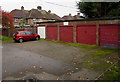
Broken Furlong lockup garages, Eton
Located on the east side of Broken Furlong, opposite the Stonebridge Field junction. http://www.geograph.org.uk/photo/4715589
A notice on the garages states These garages are managed by Radian. 1-5 Broken Furlong.
Image: © Jaggery
Taken: 24 Oct 2015
0.06 miles
10
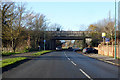
A332 bridge over B3026 Eton Wick Road
The A332 bypasses central Windsor and Eton, the old route over Windsor Bridge is now closed to motor vehicles.
Image: © Robin Webster
Taken: 8 Dec 2019
0.06 miles