IMAGES TAKEN NEAR TO
Northfield Road, WINDSOR, SL4 6LF
Introduction
This page details the photographs taken nearby to Northfield Road, SL4 6LF by members of the Geograph project.
The Geograph project started in 2005 with the aim of publishing, organising and preserving representative images for every square kilometre of Great Britain, Ireland and the Isle of Man.

There are currently over 7.5m images from over14,400 individuals and you can help contribute to the project by visiting https://www.geograph.org.uk
Image Map
Images are licensed for reuse under creativecommons.org/licenses/by-sa/2.0
Notes
- Clicking on the map will re-center to the selected point.
- The higher the marker number, the further away the image location is from the centre of the postcode.
Image Listing (12 Images Found)
Images are licensed for reuse under creativecommons.org/licenses/by-sa/2.0
Image
Details
Distance
1
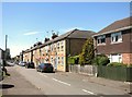
Alma Road, Eton Wick
One of many Alma Roads up and down the land, remembering the Battle of Alma, Crimean War, September 20, 1854.
Image: © Des Blenkinsopp
Taken: 13 May 2015
0.09 miles
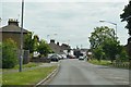
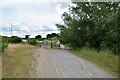
4
B3026 through Eton Wick
Heading west towards Dorney.
Image: © Robin Webster
Taken: 8 Dec 2019
0.19 miles
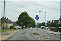
6
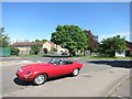
Red Car in Eton Wick
Brightens up an otherwise unremarkable scene.
Image: © Des Blenkinsopp
Taken: 13 May 2015
0.20 miles
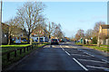
7
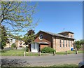
St Gilbert's Church, Eton Wick
One of three churches in the Catholic parish of Our Lady of Peace, Burnham.
Image: © Des Blenkinsopp
Taken: 13 May 2015
0.22 miles
10
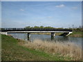
Jubilee River bridge
This bridge carries the bridleway from Eton Wick to Cippenham.
Image: © don cload
Taken: 10 Apr 2010
0.23 miles