IMAGES TAKEN NEAR TO
Maidens Green, WINDSOR, SL4 4SJ
Introduction
This page details the photographs taken nearby to Maidens Green, SL4 4SJ by members of the Geograph project.
The Geograph project started in 2005 with the aim of publishing, organising and preserving representative images for every square kilometre of Great Britain, Ireland and the Isle of Man.

There are currently over 7.5m images from over14,400 individuals and you can help contribute to the project by visiting https://www.geograph.org.uk
Image Map
Images are licensed for reuse under creativecommons.org/licenses/by-sa/2.0
Notes
- Clicking on the map will re-center to the selected point.
- The higher the marker number, the further away the image location is from the centre of the postcode.
Image Listing (23 Images Found)
Images are licensed for reuse under creativecommons.org/licenses/by-sa/2.0
Image
Details
Distance
1
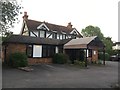
The Cinnamon Tree
An Indian restaurant in Maiden's Green
Image: © Graham Hogg
Taken: 22 May 2017
0.02 miles
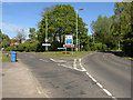
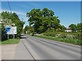
2
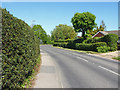
The A330, Maiden's Green
Looking east along the A330 towards the junction of Winkfield Street on the left of the bend.
Image: © Alan Hunt
Taken: 13 May 2015
0.02 miles
3

Autotek Garage, Maiden's Green
The sign has been removed from the front of the office showing the traces of the older sign for Bailey's Garage.
Image: © David Howard
Taken: 9 Mar 2014
0.03 miles
4
Maiden's Green
Looking across the corner of a field from the Bracknell Road to the saddler's shop on Maiden's Green.
Image: © Alan Hunt
Taken: 13 May 2015
0.04 miles
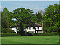
5
Maiden's Green - Victorian House on the A330
Image: © James Emmans
Taken: 31 May 2017
0.04 miles
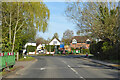
6
Maiden's Green
The junction of Winkfield Street on the left with the A330, Church Road.
Image: © Alan Hunt
Taken: 13 May 2015
0.06 miles
7
Corner on A330, Maiden's Green
Towards Maidenhead. The A330 takes an erratic route, using fragments of other routes with more direct courses between their particular end points.
Image: © Robin Webster
Taken: 18 Apr 2021
0.06 miles
8
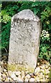
Old Milestone by the B3022, Maiden's Green
Carved stone post by the B3022, in parish of Winkfield (Bracknell Forest District), Maiden's Green; at junction with Bracknell Road with A330, opposite Handpost Farm, set in pebbles on grass verge, on East side of road. Forest square, erected by the Forest Road (not a Turnpike) turnpike trust in the 19th century.
Inscription reads:-
HYDE PARK
CORNER
26
MILES
READING
14
MILES
Grade II listed.
List Entry Number: 1390426 https://historicengland.org.uk/listing/the-list/list-entry/1390426
Milestone Society National ID: BE_LRF26
Image: © A Rosevear
Taken: 13 Jun 2002
0.08 miles
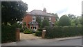
9
Maidens Green at the junction of Bracknell Road
Image: © David Howard
Taken: 9 Mar 2014
0.09 miles
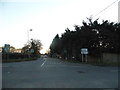
10
Bracknell Road, Maiden's Green
Looking north along Bracknell Road towards the crossroads with the A330 in Maiden's Green.
Image: © Alan Hunt
Taken: 13 May 2015
0.09 miles