IMAGES TAKEN NEAR TO
Millside Park, Crouch Lane, WINDSOR, SL4 4PX
Introduction
This page details the photographs taken nearby to Millside Park, Crouch Lane, SL4 4PX by members of the Geograph project.
The Geograph project started in 2005 with the aim of publishing, organising and preserving representative images for every square kilometre of Great Britain, Ireland and the Isle of Man.

There are currently over 7.5m images from over14,400 individuals and you can help contribute to the project by visiting https://www.geograph.org.uk
Image Map
Images are licensed for reuse under creativecommons.org/licenses/by-sa/2.0
Notes
- Clicking on the map will re-center to the selected point.
- The higher the marker number, the further away the image location is from the centre of the postcode.
Image Listing (6 Images Found)
Images are licensed for reuse under creativecommons.org/licenses/by-sa/2.0
Image
Details
Distance
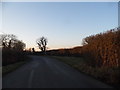
1
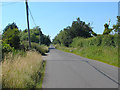
The long straight road
A view along Crouch Lane that runs between North Street and Winkfield Lane.
Image: © Alan Hunt
Taken: 24 Jul 2012
0.07 miles
3
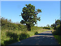
Hedgerow oak, Crouch Lane
An old oak in the hedgerow of Crouch Lane. the farm on the other side of the hedge is called Old Oaks Farm.
Image: © Alan Hunt
Taken: 24 Jul 2012
0.16 miles
5
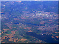
Windsor from the air
Dorney rowing lake is prominent in the centre of the photo.
Image: © Thomas Nugent
Taken: 11 Oct 2010
0.21 miles