IMAGES TAKEN NEAR TO
Frances Road, WINDSOR, SL4 3UU
Introduction
This page details the photographs taken nearby to Frances Road, SL4 3UU by members of the Geograph project.
The Geograph project started in 2005 with the aim of publishing, organising and preserving representative images for every square kilometre of Great Britain, Ireland and the Isle of Man.

There are currently over 7.5m images from over14,400 individuals and you can help contribute to the project by visiting https://www.geograph.org.uk
Image Map
Images are licensed for reuse under creativecommons.org/licenses/by-sa/2.0
Notes
- Clicking on the map will re-center to the selected point.
- The higher the marker number, the further away the image location is from the centre of the postcode.
Image Listing (302 Images Found)
Images are licensed for reuse under creativecommons.org/licenses/by-sa/2.0
Image
Details
Distance
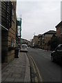
2
Boundary of Sheet Street and Kings Road
Image: © Basher Eyre
Taken: 17 Feb 2009
0.02 miles
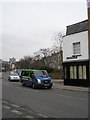
3
Junction of Frances Road and Allkins Court
Image: © Basher Eyre
Taken: 17 Feb 2009
0.02 miles
4
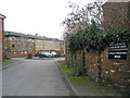
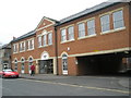
Car park for Allkins Court
Just off Frances Road.
Image: © Basher Eyre
Taken: 17 Feb 2009
0.03 miles


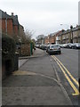
8

Junction of Frances Road and the eastern part of Grove Road
Image: © Basher Eyre
Taken: 17 Feb 2009
0.06 miles

10
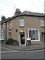
The Ironing Shop
On the corner of Frances Road and Grove Road.
Image: © Basher Eyre
Taken: 17 Feb 2009
0.08 miles