IMAGES TAKEN NEAR TO
Trinity Place, WINDSOR, SL4 3AT
Introduction
This page details the photographs taken nearby to Trinity Place, SL4 3AT by members of the Geograph project.
The Geograph project started in 2005 with the aim of publishing, organising and preserving representative images for every square kilometre of Great Britain, Ireland and the Isle of Man.

There are currently over 7.5m images from over14,400 individuals and you can help contribute to the project by visiting https://www.geograph.org.uk
Image Map
Images are licensed for reuse under creativecommons.org/licenses/by-sa/2.0
Notes
- Clicking on the map will re-center to the selected point.
- The higher the marker number, the further away the image location is from the centre of the postcode.
Image Listing (228 Images Found)
Images are licensed for reuse under creativecommons.org/licenses/by-sa/2.0
Image
Details
Distance
3
Holy Trinity Church Windsor
On Trinity Place
Image: © David Howard
Taken: 28 Mar 2011
0.02 miles
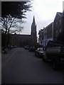
8
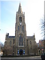
Windsor: Holy Trinity Church
This is the west façade with its tower, viewed looking up Claremont Road. Please see Image for brief details of its history.
Image: © Nigel Cox
Taken: 28 Nov 2010
0.05 miles
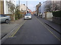
10
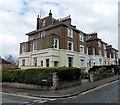
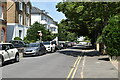
3-storey houses, Claremont Road, Windsor
The houses are on the north side of Claremont Road, viewed from the corner of Dorset Road.
Image: © Jaggery
Taken: 27 Apr 2013
0.05 miles