IMAGES TAKEN NEAR TO
Malt House Close, WINDSOR, SL4 2SD
Introduction
This page details the photographs taken nearby to Malt House Close, SL4 2SD by members of the Geograph project.
The Geograph project started in 2005 with the aim of publishing, organising and preserving representative images for every square kilometre of Great Britain, Ireland and the Isle of Man.

There are currently over 7.5m images from over14,400 individuals and you can help contribute to the project by visiting https://www.geograph.org.uk
Image Map
Images are licensed for reuse under creativecommons.org/licenses/by-sa/2.0
Notes
- Clicking on the map will re-center to the selected point.
- The higher the marker number, the further away the image location is from the centre of the postcode.
Image Listing (101 Images Found)
Images are licensed for reuse under creativecommons.org/licenses/by-sa/2.0
Image
Details
Distance
1
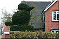
Old Windsor - Topiary
An interesting example of topiary in a house beside the A308 in Old Windsor.
Image: © Brendan and Ruth McCartney
Taken: 11 Jan 2005
0.02 miles
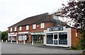
3
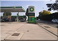
BP petrol station on Straight Road, Old Windsor
Image: © David Howard
Taken: 9 Mar 2014
0.04 miles
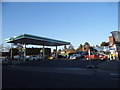
4
BP garage on Straight Road, Old Windsor
Image: © David Howard
Taken: 29 May 2016
0.04 miles
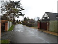
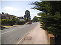
6
Walpole Road
Early spring flowers in Walpole Road.
Image: © don cload
Taken: 22 Feb 2011
0.10 miles
7

Bells of Ouzeley, Old Windsor
Old Windsor's Harvester pub
Image: © Robert Eva
Taken: 5 Jan 2017
0.12 miles
8
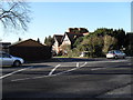
Looking across Straight Road into Orchard Road
Image: © Basher Eyre
Taken: 2 Jan 2010
0.12 miles
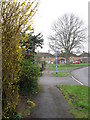
9
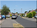
Mills Spur
One of the cul-de-sacs off Ashbrook road in Old Windsor.
Image: © Alan Hunt
Taken: 18 Jul 2013
0.13 miles