IMAGES TAKEN NEAR TO
Glebe Road, WINDSOR, SL4 2PN
Introduction
This page details the photographs taken nearby to Glebe Road, SL4 2PN by members of the Geograph project.
The Geograph project started in 2005 with the aim of publishing, organising and preserving representative images for every square kilometre of Great Britain, Ireland and the Isle of Man.

There are currently over 7.5m images from over14,400 individuals and you can help contribute to the project by visiting https://www.geograph.org.uk
Image Map
Images are licensed for reuse under creativecommons.org/licenses/by-sa/2.0
Notes
- Clicking on the map will re-center to the selected point.
- The higher the marker number, the further away the image location is from the centre of the postcode.
Image Listing (147 Images Found)
Images are licensed for reuse under creativecommons.org/licenses/by-sa/2.0
Image
Details
Distance
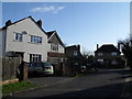
2
Approaching the junction of Glebe Road and Church Road
Image: © Basher Eyre
Taken: 2 Jan 2010
0.03 miles


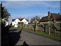
8
Approaching the junction of Church Road and Glebe Road
Image: © Basher Eyre
Taken: 2 Jan 2010
0.04 miles
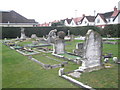
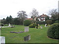
10
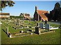
Old Windsor Cemetery
The cemetery is on Church Road. The building is the former mortuary chapel built in 1886, restored in 1994, converted to the Old Windsor Parish Council Meeting Room, and opened as such on 7 January 1995 on the centenary of the Parish Council.
Image: © Nigel Cox
Taken: 7 Dec 2008
0.04 miles