IMAGES TAKEN NEAR TO
Ham Island, WINDSOR, SL4 2JU
Introduction
This page details the photographs taken nearby to Ham Island, SL4 2JU by members of the Geograph project.
The Geograph project started in 2005 with the aim of publishing, organising and preserving representative images for every square kilometre of Great Britain, Ireland and the Isle of Man.

There are currently over 7.5m images from over14,400 individuals and you can help contribute to the project by visiting https://www.geograph.org.uk
Image Map
Images are licensed for reuse under creativecommons.org/licenses/by-sa/2.0
Notes
- Clicking on the map will re-center to the selected point.
- The higher the marker number, the further away the image location is from the centre of the postcode.
Image Listing (65 Images Found)
Images are licensed for reuse under creativecommons.org/licenses/by-sa/2.0
Image
Details
Distance
1
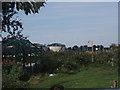
Sewage works at Ham Island
It is hard to believe just yards away from here is a row of exclusive riverside homes.
Image: © Basher Eyre
Taken: 18 Sep 2006
0.01 miles
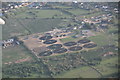
2
Thames Water Site Entrance, Ham Island
Most of Ham Island's 50 hectares is occupied by a Thames Water sewage treatment works. https://en.wikipedia.org/wiki/Ham_Island
The island also has a resident population of just under 40 households.
Image: © Des Blenkinsopp
Taken: 6 Feb 2020
0.06 miles
3
Ham island sewage works
The entrance to the sewage treatment plant on ham Island in the River Thames.
Image: © Alan Hunt
Taken: 3 Oct 2014
0.08 miles
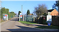
5
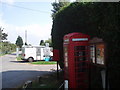
Phone box by entrance to Ham Lane
Note the signs detailing that the road is private, run by and for the "Ham Island Residents Association"
Image: © Basher Eyre
Taken: 9 Sep 2007
0.11 miles
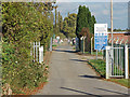
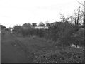
6
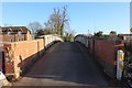
Ham Bridge
The road to the sewage works on Ham Island
Image: © Robert Eva
Taken: 5 Jan 2017
0.12 miles
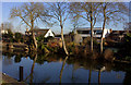
7
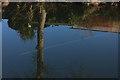
Reflections - trees and vapour trails
The Thames near Ham Bridge
Image: © Robert Eva
Taken: 5 Jan 2017
0.12 miles
8
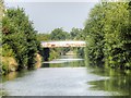
Ham Island Bridge, River Thames New Cut
Ham Island is an inhabited man-made island of roughly 50 hectares (125 acres) in the River Thames at Old Windsor. It was a peninsula partly surrounded by a meander until 1822, when a channel of the river was made, the New Cut, to build Old Windsor Lock at its downstream end, a weir along the mainstream and smaller weir at the end of the cut. Accordingly the distance in navigation has been cut to around one third.
The bridge is private, as is all of Ham Island, with no public access.
Image: © David Dixon
Taken: 18 Jul 2014
0.13 miles
9
Ham Bridge
From the Thames Path. The bridge crosses the lock cut.
Image: © Eirian Evans
Taken: 27 Nov 2013
0.13 miles
10
New Cut
This cuts off a loop of the Thames and forms Ham Island.
Image: © Robert Eva
Taken: 5 Jan 2017
0.13 miles