IMAGES TAKEN NEAR TO
Ham Island, WINDSOR, SL4 2JT
Introduction
This page details the photographs taken nearby to Ham Island, SL4 2JT by members of the Geograph project.
The Geograph project started in 2005 with the aim of publishing, organising and preserving representative images for every square kilometre of Great Britain, Ireland and the Isle of Man.

There are currently over 7.5m images from over14,400 individuals and you can help contribute to the project by visiting https://www.geograph.org.uk
Image Map
Images are licensed for reuse under creativecommons.org/licenses/by-sa/2.0
Notes
- Clicking on the map will re-center to the selected point.
- The higher the marker number, the further away the image location is from the centre of the postcode.
Image Listing (69 Images Found)
Images are licensed for reuse under creativecommons.org/licenses/by-sa/2.0
Image
Details
Distance
1
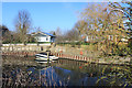
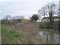
Ham Island from the Thames Path
Looking across the New Cut which created the man made Ham Island in 1822 by making a navigation canal to avoid a long river meander. In common with many other larger Thames islands, Ham Island has a resident population. The houses are on the south side of the island, the rest of which is mostly occupied by a Thames Water sewage works.
Image: © Des Blenkinsopp
Taken: 6 Feb 2020
0.02 miles
2
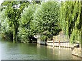
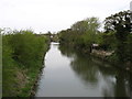
River Thames New Cut, Ham Island
Ham Island is an inhabited man-made island of roughly 50 hectares (125 acres) in the River Thames at Old Windsor. It was a peninsula partly surrounded by a meander until 1822, when a channel of the river was made, the New Cut, to build Old Windsor Lock at its downstream end.
Image: © David Dixon
Taken: 18 Jul 2014
0.02 miles
3
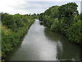
River Thames: The New Cut in Old Windsor
It's called the New Cut but was actually dug out as long ago as 1822. It was constructed across the neck of a large meander of the River Thames in Old Windsor, with a view to shortening the navigable distance along the river. The cut-off land is now known as Ham Island and this view was taken looking upstream from Ham Bridge.
Image: © Nigel Cox
Taken: 8 Jul 2008
0.03 miles
4
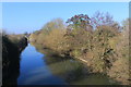
The New Cut at Ham Island
A navigation canal which cuts off a wide river meander, creating Ham Island in the process.
Image: © Des Blenkinsopp
Taken: 6 Feb 2020
0.03 miles
5
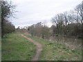
Thames Path beside New Cut
Thames Path beside New Cut adjacent to Ham Island.
Image: © Philip Halling
Taken: 29 Aug 2011
0.03 miles
6
The New Cut from the bridge leading to Ham Island
The Thames Path runs behind the bushes on the left.
Image: © David Purchase
Taken: 28 Apr 2013
0.05 miles
7
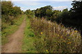
River Thames path
The Thames path running along the New Cut north of Ham Lane.
Image: © Alan Hunt
Taken: 3 Oct 2014
0.05 miles
8
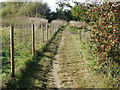
Thames Path running past Old Windsor Lock Cut
Image: © Basher Eyre
Taken: 28 Mar 2010
0.06 miles
10
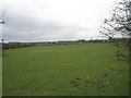
Field adjacent to Old Windsor Lock Cut
Image: © Basher Eyre
Taken: 28 Mar 2010
0.06 miles