IMAGES TAKEN NEAR TO
Ham Lane, WINDSOR, SL4 2JS
Introduction
This page details the photographs taken nearby to Ham Lane, SL4 2JS by members of the Geograph project.
The Geograph project started in 2005 with the aim of publishing, organising and preserving representative images for every square kilometre of Great Britain, Ireland and the Isle of Man.

There are currently over 7.5m images from over14,400 individuals and you can help contribute to the project by visiting https://www.geograph.org.uk
Image Map
Images are licensed for reuse under creativecommons.org/licenses/by-sa/2.0
Notes
- Clicking on the map will re-center to the selected point.
- The higher the marker number, the further away the image location is from the centre of the postcode.
Image Listing (68 Images Found)
Images are licensed for reuse under creativecommons.org/licenses/by-sa/2.0
Image
Details
Distance
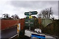
1
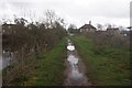
Ham Island Bridge on a dull March afternoon
Image: © Basher Eyre
Taken: 28 Mar 2010
0.01 miles
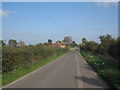
2
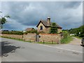
Isolated House on Ham Lane
The Thames Path Trail run next to the house along the River Thames.
Image: © James Emmans
Taken: 9 Jun 2017
0.02 miles
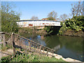
4
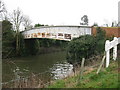
Ham Bridge
The only bridge to Ham Island.
Image: © don cload
Taken: 22 Feb 2011
0.02 miles
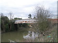
5
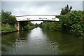
Ham Bridge
This provides access to Ham Island where there are a few houses and a sewage works. This New Cut cuts off well over a mile of river.
Image: © Graham Horn
Taken: 24 Aug 2008
0.02 miles
6
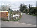
Junction of Ham Lane and the access road to Old Windsor Lock
Image: © Basher Eyre
Taken: 28 Mar 2010
0.02 miles
8
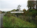
Ham Bridge
This rather uninspiring edifice spans New Cut and provides the only (limited) road access to Ham Island.
Image: © Martyn B
Taken: 23 Oct 2005
0.02 miles