IMAGES TAKEN NEAR TO
Crimp Hill Road, WINDSOR, SL4 2HL
Introduction
This page details the photographs taken nearby to Crimp Hill Road, SL4 2HL by members of the Geograph project.
The Geograph project started in 2005 with the aim of publishing, organising and preserving representative images for every square kilometre of Great Britain, Ireland and the Isle of Man.

There are currently over 7.5m images from over14,400 individuals and you can help contribute to the project by visiting https://www.geograph.org.uk
Image Map
Images are licensed for reuse under creativecommons.org/licenses/by-sa/2.0
Notes
- Clicking on the map will re-center to the selected point.
- The higher the marker number, the further away the image location is from the centre of the postcode.
Image Listing (6 Images Found)
Images are licensed for reuse under creativecommons.org/licenses/by-sa/2.0
Image
Details
Distance
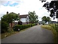
1
The entrance to The Dower House on Crimp Hill
Image: © David Howard
Taken: 18 Jan 2015
0.07 miles
2
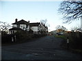
Newsworthy?
Television outdoor broadcasting vans at the front entrance of someone once connected to a man born in this square Image
Image: © Ian Paterson
Taken: 21 Dec 2014
0.07 miles
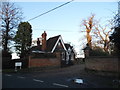
3

Tree lined drive to Woodside
Tree lined drive to Woodside near to Old Windsor
Image: © Shaun Ferguson
Taken: 14 Sep 2007
0.10 miles
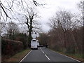
4
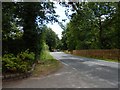
Crimp Hill near Woodside
Minor rural road near Windsor Great Park.
Image: © James Emmans
Taken: 25 Jun 2017
0.13 miles