IMAGES TAKEN NEAR TO
Albert Road, WINDSOR, SL4 2FE
Introduction
This page details the photographs taken nearby to Albert Road, SL4 2FE by members of the Geograph project.
The Geograph project started in 2005 with the aim of publishing, organising and preserving representative images for every square kilometre of Great Britain, Ireland and the Isle of Man.

There are currently over 7.5m images from over14,400 individuals and you can help contribute to the project by visiting https://www.geograph.org.uk
Image Map
Images are licensed for reuse under creativecommons.org/licenses/by-sa/2.0
Notes
- Clicking on the map will re-center to the selected point.
- The higher the marker number, the further away the image location is from the centre of the postcode.
Image Listing (9 Images Found)
Images are licensed for reuse under creativecommons.org/licenses/by-sa/2.0
Image
Details
Distance
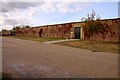
1
Indian Kiosk Frogmore Estate Windsor
Image: © Antony WyrdLight McCallum
Taken: 18 May 2006
0.15 miles

4
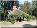
Queen Victoria's Tea House on the Frogmore Estate
This photo shows the brick and tiled Tea House which was built for Queen Victoria in the south-eastern corner of the garden. This building dates from 1869-70, and during the Summer, the Queen would often work in a tent erected close to the Tea House.
Image: © David Hillas
Taken: 15 Sep 2012
0.23 miles
6
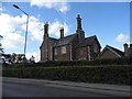
House on Albert Road, Windsor
Probably Victorian Gothic style
Image: © David Howard
Taken: 3 May 2015
0.23 miles
7
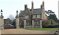
Albert Lodge, Windsor.
View of a fine old building, Lodge House to the Royal Gardens.
Image: © Stephen Elwyn RODDICK
Taken: 2 Jan 2006
0.23 miles