IMAGES TAKEN NEAR TO
Mayfield Place, WINDSOR, SL4 2FA
Introduction
This page details the photographs taken nearby to Mayfield Place, SL4 2FA by members of the Geograph project.
The Geograph project started in 2005 with the aim of publishing, organising and preserving representative images for every square kilometre of Great Britain, Ireland and the Isle of Man.

There are currently over 7.5m images from over14,400 individuals and you can help contribute to the project by visiting https://www.geograph.org.uk
Image Map
Images are licensed for reuse under creativecommons.org/licenses/by-sa/2.0
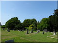
Notes
- Clicking on the map will re-center to the selected point.
- The higher the marker number, the further away the image location is from the centre of the postcode.
Image Listing (70 Images Found)
Images are licensed for reuse under creativecommons.org/licenses/by-sa/2.0
Image
Details
Distance
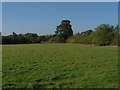
1
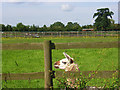
Grazing land, Cranbourne
A footpath crosses fields of various animals between Hatchet Lane and North Street.
Image: © Andrew Smith
Taken: 5 Jun 2008
0.16 miles
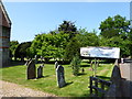
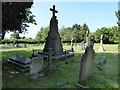

8
Field, Cranbourne
A view of the field at the back of St Peter's churchyard.
Image: © Alan Hunt
Taken: 22 Oct 2011
0.20 miles
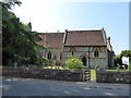
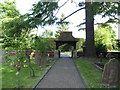
9

St Peter, Cranbourne: stained glass window (J)
Image: © Basher Eyre
Taken: 6 Jun 2016
0.20 miles