IMAGES TAKEN NEAR TO
Lovel Road, WINDSOR, SL4 2ES
Introduction
This page details the photographs taken nearby to Lovel Road, SL4 2ES by members of the Geograph project.
The Geograph project started in 2005 with the aim of publishing, organising and preserving representative images for every square kilometre of Great Britain, Ireland and the Isle of Man.

There are currently over 7.5m images from over14,400 individuals and you can help contribute to the project by visiting https://www.geograph.org.uk
Image Map
Images are licensed for reuse under creativecommons.org/licenses/by-sa/2.0
Notes
- Clicking on the map will re-center to the selected point.
- The higher the marker number, the further away the image location is from the centre of the postcode.
Image Listing (25 Images Found)
Images are licensed for reuse under creativecommons.org/licenses/by-sa/2.0
Image
Details
Distance
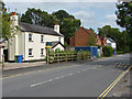
1

The Winkfield
Attractive pub and restaurant.
Image: © don cload
Taken: 26 Aug 2010
0.03 miles
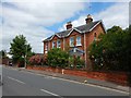
2

A330 Lovel Road, Plaistow Green
Towards Maidenhead.
Image: © Robin Webster
Taken: 18 Apr 2021
0.04 miles
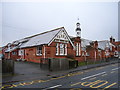
3

The Cranbourne primary school
The Cranbourne primary school on Lovel Road. The building dates from the late 19th century and was purpose built as a school.
Image: © Alan Hunt
Taken: 28 Aug 2014
0.05 miles
4

Lovel Road, Plaistow Green
Looking east along Lovel Road with Kee's oriental restaurant, formerly The Winkfield public house, in the middle distance.
Image: © Alan Hunt
Taken: 28 Aug 2014
0.06 miles
5

Former police station, Plaistow Green
The former police station next door to the Cranbourne primary school, now developed as flats and renamed Elliot Court.
Image: © Alan Hunt
Taken: 28 Aug 2014
0.07 miles
7
Cranbourne Primary School
Pictured just after the school run the school lies at the eastern extremity of the grid-square.
Image: © Andrew Smith
Taken: 24 Feb 2006
0.10 miles
8
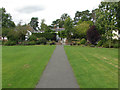
Asher Recreation Ground, Plaistow Green
The exit from the recreation ground onto Lovel Road.
Image: © Alan Hunt
Taken: 28 Aug 2014
0.13 miles
9
Lovel Road, Plaistow Green
Looking east towards the junction with Hatchet Lane.
Image: © Alan Hunt
Taken: 28 Aug 2014
0.14 miles
10
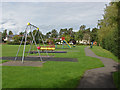
Asher Recreation Ground, Plaistow Green
The children's play area in the recreation ground off Lovel Road.
Image: © Alan Hunt
Taken: 28 Aug 2014
0.15 miles