IMAGES TAKEN NEAR TO
Lovel Lane, WINDSOR, SL4 2DG
Introduction
This page details the photographs taken nearby to Lovel Lane, SL4 2DG by members of the Geograph project.
The Geograph project started in 2005 with the aim of publishing, organising and preserving representative images for every square kilometre of Great Britain, Ireland and the Isle of Man.

There are currently over 7.5m images from over14,400 individuals and you can help contribute to the project by visiting https://www.geograph.org.uk
Image Map
Images are licensed for reuse under creativecommons.org/licenses/by-sa/2.0
Notes
- Clicking on the map will re-center to the selected point.
- The higher the marker number, the further away the image location is from the centre of the postcode.
Image Listing (7 Images Found)
Images are licensed for reuse under creativecommons.org/licenses/by-sa/2.0
Image
Details
Distance
1
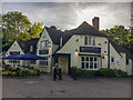
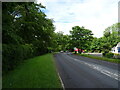
Loch Fyne Restaurant at Woodside
Formerly the Old Crispin public house
Image: © Graham Hogg
Taken: 21 May 2017
0.07 miles
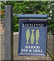
2
The Loch Fyne, Woodside
Seafood, Bar and Grill.
See Image] for sign.
Image: © JThomas
Taken: 24 May 2022
0.07 miles
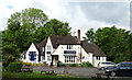
6
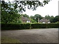
Woodend Cottages
Four Cottages in Wood End close to Windsor Road.
Image: © James Emmans
Taken: 16 Jun 2017
0.11 miles
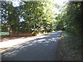
7
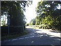
Private Road off Sunninghill Road
Much of this area is crown property and has restricted access.
Image: © David Howard
Taken: 19 Jul 2015
0.25 miles