IMAGES TAKEN NEAR TO
Ward Royal, WINDSOR, SL4 1SR
Introduction
This page details the photographs taken nearby to Ward Royal, SL4 1SR by members of the Geograph project.
The Geograph project started in 2005 with the aim of publishing, organising and preserving representative images for every square kilometre of Great Britain, Ireland and the Isle of Man.

There are currently over 7.5m images from over14,400 individuals and you can help contribute to the project by visiting https://www.geograph.org.uk
Image Map
Images are licensed for reuse under creativecommons.org/licenses/by-sa/2.0
Notes
- Clicking on the map will re-center to the selected point.
- The higher the marker number, the further away the image location is from the centre of the postcode.
Image Listing (586 Images Found)
Images are licensed for reuse under creativecommons.org/licenses/by-sa/2.0
Image
Details
Distance
1
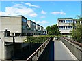
Bridge to Mountbatten Square, Windsor, Berkshire
Behind the viewpoint is a large shopping precinct. Ahead is a residential development which probably started life in the 1960s as a municipal housing project. Nowadays it is about 60% owner-occupied with the rest predominantly privately rented. Two-thirds of residents are in social classes AB and C1. Classes D and E account for almost a quarter of residents. Source: https://www.streetcheck.co.uk/postcode/sl41sz
Image: © Brian Robert Marshall
Taken: 26 May 2015
0.03 miles
2
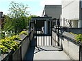
Security gate, Mountbatten Square, Windsor, Berkshire
The gate is visible left of centre in this image http://www.geograph.org.uk/photo/4496446 The gate was installed to protect residents from marauding packs of minor Royals based at the local castle.
Image: © Brian Robert Marshall
Taken: 26 May 2015
0.03 miles
4

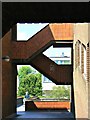
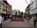
King Edward Court , Windsor
Part of a large pedestrian precinct, this particular street links King Edward Court to Peascod Street, at a lower level.
Image: © Derek Harper
Taken: 13 Jun 2010
0.04 miles


7
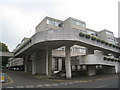
Walkway across Charles Street, Windsor, Berkshire
The walkway provides pedestrian access to and from the town's main shopping centre and an area of postwar housing. The staircases serve a multi-storey car park.
Image: © Brian Robert Marshall
Taken: 26 May 2015
0.05 miles

10
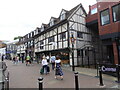
86 & 87 Peascod Street
A C16/17th Grade II listed building.
Image: © Rod Allday
Taken: 11 Sep 2021
0.05 miles