IMAGES TAKEN NEAR TO
William Street, WINDSOR, SL4 1AT
Introduction
This page details the photographs taken nearby to William Street, SL4 1AT by members of the Geograph project.
The Geograph project started in 2005 with the aim of publishing, organising and preserving representative images for every square kilometre of Great Britain, Ireland and the Isle of Man.

There are currently over 7.5m images from over14,400 individuals and you can help contribute to the project by visiting https://www.geograph.org.uk
Image Map
Images are licensed for reuse under creativecommons.org/licenses/by-sa/2.0
Notes
- Clicking on the map will re-center to the selected point.
- The higher the marker number, the further away the image location is from the centre of the postcode.
Image Listing (791 Images Found)
Images are licensed for reuse under creativecommons.org/licenses/by-sa/2.0
Image
Details
Distance
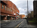
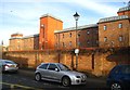
2
Victoria Street Windsor
At junction of William Street
Image: © David Howard
Taken: 28 Mar 2011
0.02 miles
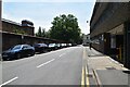
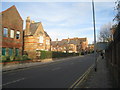
3
William Street, Windsor
One of the less picturesque thoroughfares in the town centre, linking Victoria Street (behind the photographer) with Peascod Street.
Image: © Richard Vince
Taken: 26 Dec 2015
0.02 miles
7
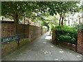
Hibberts Alley
Connecting Bachelors Acre with Mellor Walk
Image: © Dave Spicer
Taken: 30 Jul 2012
0.04 miles
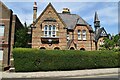
8
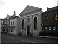
Windsor Baptist Church, Victoria Street, Windsor
Built in 1839, according to the date on the building itself.
Image: © Richard Vince
Taken: 26 Dec 2015
0.05 miles