IMAGES TAKEN NEAR TO
Welley Road, SLOUGH, SL3 9QA
Introduction
This page details the photographs taken nearby to Welley Road, SL3 9QA by members of the Geograph project.
The Geograph project started in 2005 with the aim of publishing, organising and preserving representative images for every square kilometre of Great Britain, Ireland and the Isle of Man.

There are currently over 7.5m images from over14,400 individuals and you can help contribute to the project by visiting https://www.geograph.org.uk
Image Map
Images are licensed for reuse under creativecommons.org/licenses/by-sa/2.0
Notes
- Clicking on the map will re-center to the selected point.
- The higher the marker number, the further away the image location is from the centre of the postcode.
Image Listing (46 Images Found)
Images are licensed for reuse under creativecommons.org/licenses/by-sa/2.0
Image
Details
Distance
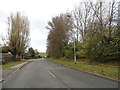
1
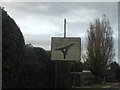
Roundabout sign on Welley Road, Sunnymeads
This uses the 1960s style roundabout symbol which was not used for very long and has very few left now.
Image: © David Howard
Taken: 2 Nov 2014
0.01 miles
7
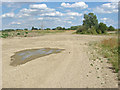
Former gravel pit
One of the recently disused gravel pits near to Wraysbury.
Image: © Alan Hunt
Taken: 15 Jul 2014
0.10 miles
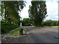
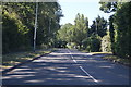
8
Junction of Welley Road and Datchet Road
Image: © Robert Eva
Taken: 31 Jul 2017
0.11 miles
9
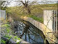
Overflow from Queen Mother Reservoir, Horton
Image: © David Dixon
Taken: 9 Apr 2015
0.12 miles
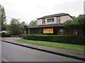
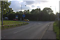
10
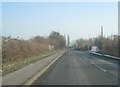
Horton Road
Running along the southern edge of The Queen Mother Reservoir.
Image: © Fernweh
Taken: 11 Feb 2012
0.13 miles