IMAGES TAKEN NEAR TO
Foundry Lane, SLOUGH, SL3 9PD
Introduction
This page details the photographs taken nearby to Foundry Lane, SL3 9PD by members of the Geograph project.
The Geograph project started in 2005 with the aim of publishing, organising and preserving representative images for every square kilometre of Great Britain, Ireland and the Isle of Man.

There are currently over 7.5m images from over14,400 individuals and you can help contribute to the project by visiting https://www.geograph.org.uk
Image Map
Images are licensed for reuse under creativecommons.org/licenses/by-sa/2.0
Notes
- Clicking on the map will re-center to the selected point.
- The higher the marker number, the further away the image location is from the centre of the postcode.
Image Listing (35 Images Found)
Images are licensed for reuse under creativecommons.org/licenses/by-sa/2.0
Image
Details
Distance
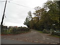
2
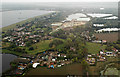
Horton from the air
Wraysbury Reservoir is on the left. Taken shortly before touchdown at Heathrow runway 09L from the west on a flight from Glasgow.
Image: © Thomas Nugent
Taken: 8 Oct 2014
0.04 miles
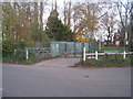
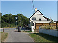
6
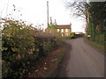
Foundry Lane at the junction of Stanwell Road
Image: © David Howard
Taken: 2 Nov 2014
0.10 miles
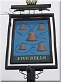
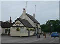
10
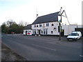
The Five Bells
The Five Bells public house on the Stanwell Road to the east of Horton. The name may reflect that the parish church nearby had a peal of five bells until 1987 when a sixth was added.
Image: © Alan Hunt
Taken: 5 Sep 2013
0.11 miles