IMAGES TAKEN NEAR TO
London Road, SLOUGH, SL3 9JN
Introduction
This page details the photographs taken nearby to London Road, SL3 9JN by members of the Geograph project.
The Geograph project started in 2005 with the aim of publishing, organising and preserving representative images for every square kilometre of Great Britain, Ireland and the Isle of Man.

There are currently over 7.5m images from over14,400 individuals and you can help contribute to the project by visiting https://www.geograph.org.uk
Image Map
Images are licensed for reuse under creativecommons.org/licenses/by-sa/2.0
Notes
- Clicking on the map will re-center to the selected point.
- The higher the marker number, the further away the image location is from the centre of the postcode.
Image Listing (211 Images Found)
Images are licensed for reuse under creativecommons.org/licenses/by-sa/2.0
Image
Details
Distance
5
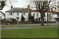
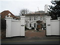
Houses on The Green, Datchet
On the right is a grade II listed house, described at https://www.historicengland.org.uk/listing/the-list/list-entry/1135871 :"C18 re-face on early C16 timber frame". The road is the B376 Horton Road.
Image: © Derek Harper
Taken: 1 Apr 2018
0.06 miles


9
![Parish church [5]](https://s1.geograph.org.uk/geophotos/07/04/05/7040557_0319e97f_120x120.jpg)
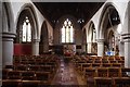
Parish church [5]
An impressive railed chest tomb in the churchyard.
The Anglican parish church of St Mary was rebuilt in 1864 with only fragments remaining of the original 13th century building. In a Gothic Revival style, the church is constructed of squared, snecked rubble stone under a plain tile roof. The church is unusual in having an octagonal broach spire. Listed, grade II, with details at: https://historicengland.org.uk/listing/the-list/list-entry/1319357
Datchet is a village on the north bank of the River Thames in the Royal Borough of Windsor and Maidenhead in Berkshire, about 1¼ miles east of Windsor. There is evidence of continuous occupation since the end of the last ice age. The village developed because of the ferry service which connected it to the main London Road across the River Thames. Now a pleasant commuter village with Waterloo station only 54 minutes away.
Image: © Michael Dibb
Taken: 19 Aug 2021
0.07 miles
10
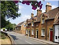
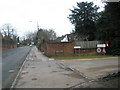
London Road, Datchet, seen from the churchyard
With James's Cottages just opposite.
Image: © Stefan Czapski
Taken: 14 Jul 2013
0.07 miles