IMAGES TAKEN NEAR TO
Penn Road, SLOUGH, SL3 9JE
Introduction
This page details the photographs taken nearby to Penn Road, SL3 9JE by members of the Geograph project.
The Geograph project started in 2005 with the aim of publishing, organising and preserving representative images for every square kilometre of Great Britain, Ireland and the Isle of Man.

There are currently over 7.5m images from over14,400 individuals and you can help contribute to the project by visiting https://www.geograph.org.uk
Image Map
Images are licensed for reuse under creativecommons.org/licenses/by-sa/2.0
Notes
- Clicking on the map will re-center to the selected point.
- The higher the marker number, the further away the image location is from the centre of the postcode.
Image Listing (25 Images Found)
Images are licensed for reuse under creativecommons.org/licenses/by-sa/2.0
Image
Details
Distance
4
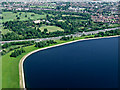
The Queen Mother Reservoir from the air
The north west corner of the reservoir. On approach to Heathrow from the west.
Image: © Thomas Nugent
Taken: 19 May 2014
0.12 miles
5
Electricity sub station, Montrose Avenue
Image: © Alex McGregor
Taken: 20 Jun 2011
0.12 miles
8
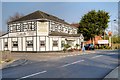
Turkish Bar & Restaurant on Horton Road, Datchet
Image: © JThomas
Taken: 27 May 2022
0.16 miles
9
Zaman Indian Restaurant, Datchet
Indian restaurant on Horton Road.
Image: © David Dixon
Taken: 9 Apr 2015
0.16 miles
10
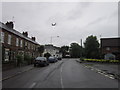
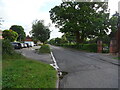
Horton Road, Datchet
Datchet is on the flightpath for London Heathrow Airport.
Image: © Ian S
Taken: 4 Jun 2012
0.17 miles