IMAGES TAKEN NEAR TO
Allen Way, SLOUGH, SL3 9HR
Introduction
This page details the photographs taken nearby to Allen Way, SL3 9HR by members of the Geograph project.
The Geograph project started in 2005 with the aim of publishing, organising and preserving representative images for every square kilometre of Great Britain, Ireland and the Isle of Man.

There are currently over 7.5m images from over14,400 individuals and you can help contribute to the project by visiting https://www.geograph.org.uk
Image Map
Images are licensed for reuse under creativecommons.org/licenses/by-sa/2.0
Notes
- Clicking on the map will re-center to the selected point.
- The higher the marker number, the further away the image location is from the centre of the postcode.
Image Listing (156 Images Found)
Images are licensed for reuse under creativecommons.org/licenses/by-sa/2.0
Image
Details
Distance
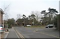
2
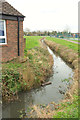
Drainage channel, Datchet
Running through the recreation ground.
Image: © Derek Harper
Taken: 1 Apr 2018
0.02 miles
5
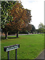
Autumn Trees
On a strip of grass between Horton Road and Allen Way.
Image: © Oast House Archive
Taken: 6 Oct 2010
0.04 miles