IMAGES TAKEN NEAR TO
The Green, SLOUGH, SL3 9EL
Introduction
This page details the photographs taken nearby to The Green, SL3 9EL by members of the Geograph project.
The Geograph project started in 2005 with the aim of publishing, organising and preserving representative images for every square kilometre of Great Britain, Ireland and the Isle of Man.

There are currently over 7.5m images from over14,400 individuals and you can help contribute to the project by visiting https://www.geograph.org.uk
Image Map
Images are licensed for reuse under creativecommons.org/licenses/by-sa/2.0
Notes
- Clicking on the map will re-center to the selected point.
- The higher the marker number, the further away the image location is from the centre of the postcode.
Image Listing (221 Images Found)
Images are licensed for reuse under creativecommons.org/licenses/by-sa/2.0
Image
Details
Distance
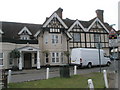
1
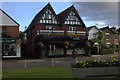
Spices restaurant on the Green at Datchet
Image: © Robert Eva
Taken: 31 Jul 2017
0.00 miles
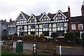
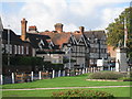
2
![Datchet buildings [8]](https://s3.geograph.org.uk/geophotos/07/04/21/7042159_cfe967c8_120x120.jpg)
Datchet buildings [8]
On The Green, the Manor House is a three bay house from the late 16th century, with a fourth bay added circa 1650. The building was refronted circa 1870. Timber framed, jettied to the street with applied framing to a plastered front, all under a tile roof. Now two dwellings. Listed, grade II, with details at: https://historicengland.org.uk/listing/the-list/list-entry/1313081
Datchet is a village on the north bank of the River Thames in the Royal Borough of Windsor and Maidenhead in Berkshire, about 1¼ miles east of Windsor. There is evidence of continuous occupation since the end of the last ice age. The village developed because of the ferry service which connected it to the main London Road across the River Thames. Now a pleasant commuter village with Waterloo station only 54 minutes away.
Image: © Michael Dibb
Taken: 19 Aug 2021
0.00 miles
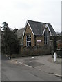
4
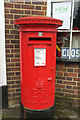
Postbox, Datchet
The post office may have closed (see Image) but Elizabeth II postbox SL3 215 is still going outside.
Image: © Derek Harper
Taken: 1 Apr 2018
0.01 miles
5
![Datchet buildings [9]](https://s0.geograph.org.uk/geophotos/07/04/21/7042160_f2e57f3d_120x120.jpg)
Datchet buildings [9]
Manor Cottage and Manor Green Cottage, The Green, were built as one house in the 16th or 17th century. Timber framed and refronted in brick in the late 18th century, all under an old tile roof. Listed, grade II, with details at: https://historicengland.org.uk/listing/the-list/list-entry/1117633
Datchet is a village on the north bank of the River Thames in the Royal Borough of Windsor and Maidenhead in Berkshire, about 1¼ miles east of Windsor. There is evidence of continuous occupation since the end of the last ice age. The village developed because of the ferry service which connected it to the main London Road across the River Thames. Now a pleasant commuter village with Waterloo station only 54 minutes away.
Image: © Michael Dibb
Taken: 19 Aug 2021
0.01 miles
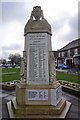
9
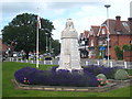
Datchet War Memorial
The oak tree in the background was planted by the children of the Datchet to celebrate Queen Victoria's Golden Jubilee in 1887.
Image: © Rod Allday
Taken: 21 Jun 2011
0.01 miles