IMAGES TAKEN NEAR TO
Montagu Road, SLOUGH, SL3 9DR
Introduction
This page details the photographs taken nearby to Montagu Road, SL3 9DR by members of the Geograph project.
The Geograph project started in 2005 with the aim of publishing, organising and preserving representative images for every square kilometre of Great Britain, Ireland and the Isle of Man.

There are currently over 7.5m images from over14,400 individuals and you can help contribute to the project by visiting https://www.geograph.org.uk
Image Map
Images are licensed for reuse under creativecommons.org/licenses/by-sa/2.0
Notes
- Clicking on the map will re-center to the selected point.
- The higher the marker number, the further away the image location is from the centre of the postcode.
Image Listing (38 Images Found)
Images are licensed for reuse under creativecommons.org/licenses/by-sa/2.0
Image
Details
Distance
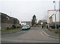
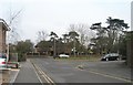
1
Datchet recreation ground
Bounded by a 20th century expansion of Datchet to the north, and the railway line to the south, is Datchet recreation ground, sometimes known as Datchet Common.
Image: © Darren Smith
Taken: 10 Jul 2005
0.11 miles
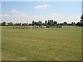
2
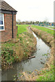
Drainage channel, Datchet
Running through the recreation ground.
Image: © Derek Harper
Taken: 1 Apr 2018
0.13 miles
3
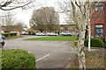
Car park, Datchet
Residents' parking off Green Lane near the Recreation Ground.
Image: © Derek Harper
Taken: 1 Apr 2018
0.13 miles
9
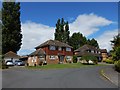
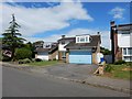
Datchet - Beaulieu Close
Detached houses on the edge of Datchet
Image: © James Emmans
Taken: 9 Jun 2017
0.16 miles