IMAGES TAKEN NEAR TO
Windsor Road, SLOUGH, SL3 9BR
Introduction
This page details the photographs taken nearby to Windsor Road, SL3 9BR by members of the Geograph project.
The Geograph project started in 2005 with the aim of publishing, organising and preserving representative images for every square kilometre of Great Britain, Ireland and the Isle of Man.

There are currently over 7.5m images from over14,400 individuals and you can help contribute to the project by visiting https://www.geograph.org.uk
Image Map
Images are licensed for reuse under creativecommons.org/licenses/by-sa/2.0
Notes
- Clicking on the map will re-center to the selected point.
- The higher the marker number, the further away the image location is from the centre of the postcode.
Image Listing (208 Images Found)
Images are licensed for reuse under creativecommons.org/licenses/by-sa/2.0
Image
Details
Distance
1
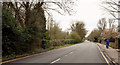
B470, Datchet
Windsor Road is followed by the Thames Path as far as where a figure is crossing the road to investigate the LDP's condition as it veers left to follow the riverbank (verdict: too muddy for us all).
Image: © Derek Harper
Taken: 1 Apr 2018
0.03 miles
2
Buccleugh Road, Datchet
A cul-de-sac seen from its junction with Queen's Road. I'm sure there will be information at http://datchethistory.org.uk/streetshouses/buccleuch-road/ , which says "coming soon" at the date of submission.
Image: © Derek Harper
Taken: 1 Apr 2018
0.05 miles
4
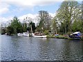
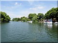
River Thames, Sumptermead Ait
Sumptermead Ait is an island in the River Thames in England on the reach above Old Windsor Lock, near Datchet Berkshire. The island is a thin wooded strip separated by a narrow channel on the Datchet side.
Image: © David Dixon
Taken: 11 Apr 2015
0.07 miles
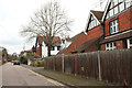
5
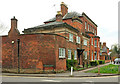
Riverside House and Corner, Datchet
On Windsor Road, at the corner of Queen's Road (left), and facing the Thames across the Thames Path. Neither part of the building, which is also shown in Image, seems to be listed, but an excellent lengthy description of the history is at http://datchethistory.org.uk/Riverside/riverside_house.htm . "Previous inhabitants have included the great cricketer Capt. Frederick Pelham Warner, MBE".
Image: © Derek Harper
Taken: 1 Apr 2018
0.07 miles
6
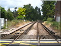
The Staines to Windsor railway line at Datchet
Seen from the level crossing in Queen's Road.
Image: © Rod Allday
Taken: 21 Jun 2011
0.08 miles
7
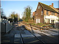
Datchet: Mays Crossing
Mays Crossing is one of the two level crossings in Datchet, and takes Queen's Road over the railway line to and from Windsor Riverside station. The other level crossing is next to the station. This is viewed looking in the direction of Windsor on a day when no trains were running due to engineering works at the other level crossing. See Image
Image: © Nigel Cox
Taken: 7 Dec 2008
0.08 miles
8
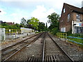
Railway towards Windsor
From the level crossing on Queen's Road.
Image: © JThomas
Taken: 27 May 2022
0.08 miles
9
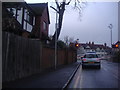
Level crossing on Queens Road, Datchet
The shops can be seen on The Green ahead.
Image: © David Howard
Taken: 13 Feb 2012
0.08 miles