IMAGES TAKEN NEAR TO
The Myrke, SLOUGH, SL3 9AD
Introduction
This page details the photographs taken nearby to The Myrke, SL3 9AD by members of the Geograph project.
The Geograph project started in 2005 with the aim of publishing, organising and preserving representative images for every square kilometre of Great Britain, Ireland and the Isle of Man.

There are currently over 7.5m images from over14,400 individuals and you can help contribute to the project by visiting https://www.geograph.org.uk
Image Map
Images are licensed for reuse under creativecommons.org/licenses/by-sa/2.0
Notes
- Clicking on the map will re-center to the selected point.
- The higher the marker number, the further away the image location is from the centre of the postcode.
Image Listing (49 Images Found)
Images are licensed for reuse under creativecommons.org/licenses/by-sa/2.0
Image
Details
Distance
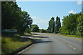
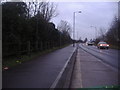
1
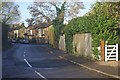
The Myrke
Part of the old Slough - Datchet road, now by-passed.
Image: © Stephen McKay
Taken: 12 Dec 2011
0.03 miles
3
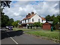
Myrke
Houses in a cul-de-sac called 'The Myrke'.
Image: © James Emmans
Taken: 9 Jun 2017
0.05 miles
4
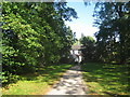
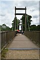
Approaching Myrke
On the footpath from Eton just after crossing the Jubilee River.
Image: © Jonathan Thacker
Taken: 11 Oct 2010
0.07 miles
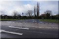
6
Slough Road entering Slough from Datchet
This is the border between Datchet and Slough, the sign behind the orange car says Slough.
Image: © David Howard
Taken: 13 Feb 2012
0.08 miles
7
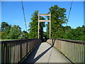
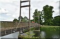
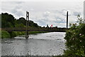
Orange Way after Wiltshire (456)
This is the crossing of the Jubilee River at Myrke. See http://en.wikipedia.org/wiki/Jubilee_River.
Image: © Shazz
Taken: 31 Aug 2013
0.09 miles