IMAGES TAKEN NEAR TO
Deverills Way, SLOUGH, SL3 8WN
Introduction
This page details the photographs taken nearby to Deverills Way, SL3 8WN by members of the Geograph project.
The Geograph project started in 2005 with the aim of publishing, organising and preserving representative images for every square kilometre of Great Britain, Ireland and the Isle of Man.

There are currently over 7.5m images from over14,400 individuals and you can help contribute to the project by visiting https://www.geograph.org.uk
Image Map
Images are licensed for reuse under creativecommons.org/licenses/by-sa/2.0
Notes
- Clicking on the map will re-center to the selected point.
- The higher the marker number, the further away the image location is from the centre of the postcode.
Image Listing (14 Images Found)
Images are licensed for reuse under creativecommons.org/licenses/by-sa/2.0
Image
Details
Distance
1
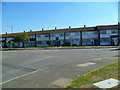
A Small Park by Grasholm Way
New housing around a green off Sutton Lane.
Image: © Des Blenkinsopp
Taken: 6 Nov 2017
0.07 miles


6
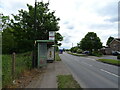
Bus stop and shelter on Sutton Lane, Slough
Image: © JThomas
Taken: 23 May 2022
0.12 miles
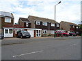
7
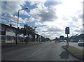
Parlaunt Road at the junction of Market Lane
Image: © David Howard
Taken: 11 May 2014
0.13 miles